More towns under threat as strong winds fan fires
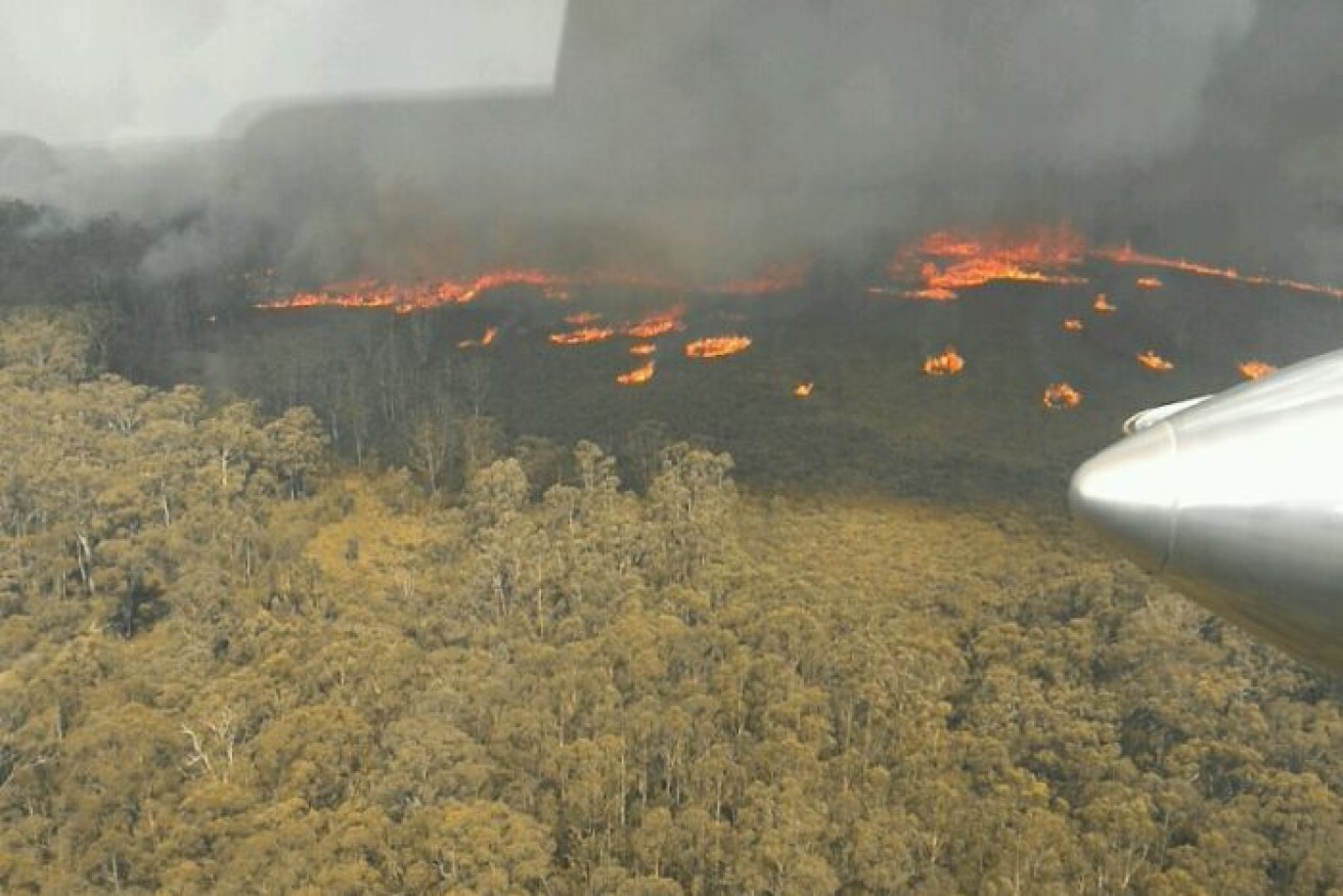
Victorian firefighters are battling blazes across the state, including East Gippsland (pictured). Photo: DELWP Gippsland
Volunteer firefighters left reeling from the death of a third colleague continue to brave multiple emergency blazes still burning across NSW while more eastern Victorian townships are now under threat.
Four fires in NSW were considered emergency level as of 7am Tuesday, while another eight were at that level in Victoria as strong winds fanned flames.
At 6.07am, Victorian authorities confirmed fire was now threatening the town of Orbost. They warned residents and holidaymakers it was too late to leave.
Meanwhile, 145km away in seaside Mallacoota, those left stranded by Monday’s severe conditions were bracing as winds were expected to fan a fire authorities warned could approach the western border of the township.
It was estimated fires had ripped through more than 200,000 hectares in East Gippsland by early Tuesday morning, and authorities confirmed homes would have been scorched.
Incident controller Chris Eagle told the ABC that lightning in the region sparked “hundreds” of new fires overnight as fires created their own weather systems.
“There’s a lot of fire, a lot of activity, there’s likely to be impact to residents because of just the sheer size – exactly how many, where they are, what that means we don’t know yet,” Mr Eagle said.
“We do know that the fire has increased immensely in size.
“The satellite took an image of some of the heat tracks, it’s several hours old now, but it’s probably close to at least 60 per cent larger than it was yesterday, so much, much larger and that starts right up north of Gelantipy.”
- For up-to-date fire warnings, see the Vic Emergency map
It came after flames lapped Melbourne’s north on Monday afternoon, threatening residential homes at Bundoora, Greenborough and Mill Park. That warning was downgraded and remained at advice level on Tuesday morning.
The winds are manic and hot like we’re in an oven. Used to feeling this near rural bushfires but this is Bundoora in Melbourne’s north. @abcnews @abcmelbourne pic.twitter.com/BLhP5ujSG5
— Emilia Terzon (@EmiliaTerzon) December 30, 2019
In Victoria’s west, flames as high as 20m had confronted fire crews battling catastrophic dangers, with 14km high smoke columns creating fire-generated thunderstorms.
The dangerous wind shift is expected to create damaging conditions and remain a risk across eastern parts of Victoria into Tuesday morning.
Victoria bushfire alerts
Midnight update: East Gippsland was ablaze late on Monday as more than 30 bushfires ravaged Victoria.
A cool change was moving across the state, with temperatures forecast to drop to the mid-20s along with high winds and thunderstorms.
Homes and lives were under threat as 13 emergency alerts were still in place for out-of-control blazes in Victoria’s far east and northeast.
A large uncontrolled fire moving from the NSW border prompted an evacuation alert for residents in Walwa.
“Firefighters have been unable to stop the fire and it has now crossed into Victoria and is moving towards Walwa, Guys Creek, Cudgewa, Burrowa Pine National Park,” the alert said.
Victorian Premier Daniel Andrews returned from holiday on Monday afternoon and was visiting the state control centre.
Emergency services had encouraged residents and holiday-makers on Sunday to leave East Gippsland, where two out-of-control bushfires merged early on Monday morning.
This message shifted as roads closed and changing conditions sparked new fires.
“The highly recommended strategy is – do not be on the roads. It is too dangerous to be driving,” police minister Lisa Neville said on Monday.
“Not only just from smoke, but because of the erratic nature and the fast-moving nature of these fires in East Gippsland.”
Wendi Perkins, who owns the Bamboo Motor Inn at Lakes Entrance: “I can’t believe the amount of people that weren’t aware they should have been leaving earlier… Now they’re all locked in and they’re saying, ‘Wow, we didn’t know this was going to happen’”
— Susan Metcalfe (@susanamet) December 30, 2019
The Princes Highway in East Gippsland is closed in both directions between Bairnsdale and Genoa due to increased fire activity.
Access to the Princes Highway towards Eden, NSW from Mallacoota and Genoa is also now closed.
The Great Alpine Road between Bruthen and Ensay could be shut for up to a fortnight.
“It is unpredictable, it’s dangerous out there. A fire that started mid afternoon moved about 24 km within four or five hours as the wind changed direction,” Emergency Management Commissioner Andrew Crisp said.
“It put up a column, punching into the atmosphere 14km high. These columns are generating their own weather. There’s lightning coming out of these columns.”
The weather change was forecast to hit East Gippsland around midnight and push temperatures lower as it moves through.
“For the whole night in eastern Gippsland we’re going to have unstable conditions, we’re going to have the fires, and the change moving through.,” Bureau of Meteorology Victoria State Manager Andrew Tupper said.
“Of course, when a wind change hits fires, then that can also greatly aggravate the spread of those fires. To complicate things even further, there is a little bit of rain with the storms.”
NSW
A firefighter lost his life in a truck rollover while battling the Green Valley blaze near Albury, not far from the Victorian border.
It was one of three NSW blazes subject to emergency warnings on Monday evening.
Another five were subject to watch-and-act alerts, including the massive Currowan fire’s western flank dubbed the Charleys Forest blaze.
A fire-generated thunderstorm (pyro-cumulonimbus) formed over the Badja Forest Road and Tuross Falls Road fires, northwest of Cobargo.
A pyro-cumulonimbus can create erratic winds and dry lightning and result in significantly faster fire spread.
A fire-generated thunderstorm has formed over the Badja Forest Road and Tuross Falls Road fires, north-west of Cobargo. This is a very dangerous situation. Monitor the conditions around you and take appropriate action. #nswfires #nswrfs pic.twitter.com/bJAGGP1LMg
— NSW RFS (@NSWRFS) December 30, 2019
Across NSW, more than 900 homes have been destroyed but that number is expected to increase with rising temperatures and dry winds forecast to peak on New Year’s Eve.
However the NSW RFS has approved Sydney’s New Year’s Eve fireworks celebrations.
Temperatures are forecast to climb past 40C in western Sydney and parts of regional NSW by Tuesday, as air pollution in the city’s southwest remains at a hazardous level.
South Australia
In South Australia, fires continue to burn on Kangaroo Island and a catastrophic danger has been declared for the Adelaide Metropolitan, Yorke Peninsula, Mount Lofty Ranges and the state’s Mid North.
Adelaide is forecast to reach 40C and firefighters are particularly worried about the potential for breakouts in the blaze burning in the Adelaide Hills.
Severe thunderstorm warnings have also been issued for parts of the South Australian coast, adding to the risk of bushfires from lightning strikes.
Tasmania
Hobart sweltered through what appears to be the city’s hottest December day on record, as two raging bushfires threaten homes elsewhere in the state.
The Tasmanian capital hit 40.8C early on Monday afternoon, while several other locations in the southeast also passed 40C.
The Bureau of Meteorology said the figures were still subject to verification.
Hobart’s previous hottest December day was recorded in 1897 when the temperature reached 40.6C, coincidentally also on the 30th.
About 20 properties were on Monday evening at risk from a blaze at Pelham in the Derwent Valley west of Hobart, which sparked two emergency warnings.
Crews had to be pulled back from the blaze due to the size of flames, Peter Middleton from the Tasmania Fire Service told ABC Radio.
Mr Middleton said Monday’s scorching temperatures and forecast high winds into the night were a “recipe for disaster”.
“It makes it very challenging for our crews. Temperatures will cool but we’re expecting the winds to pick up, which will prove challenging,” he said.
Another blaze in Tasmania’s northeast prompted emergency warnings for the town of Fingal, plus Mangana and Tower Hill, with residents told to head to a safer location.
A cool change is forecast on Tuesday, when the TFS hopes to conduct aerial patrols to look for fires sparked by dry lightning strikes from passing thunderstorms.
-with AAP
