‘Visions of March 2023’: Tense wait for north-west Queensland
A nervous wait lies ahead for north-west Queensland, with ex-Tropical Cyclone Kirrily set to bring more rain and flooding.
Almost a week after making landfall near Townsville as a category two cyclone, Kirrily is still lingering.
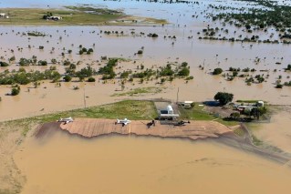
The cyclone’s remnants have been in the state’s north-west for days, bringing widespread rain and flooding.
Roads are cut, rail networks affected, Kynuna residents have been evacuated and the town of McKinlay is isolated.
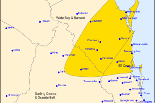
Now a remote region is bracing for the worst with ex-Kirrily’s presence sparking a severe weather warning for Gulf Country that is expected to last through to Friday.
Heavy downpours including isolated falls of 300 millimetres are possible and may lead to “life threatening” flash flooding.
The former cyclone has lingered near Burketown, triggering locals who are still reeling from a March 2023 disaster.
Burketown was evacuated last year after torrential rain led to record river levels and “unprecedented” flooding in the remote Gulf of Carpentaria.
“There’s a lot of really nervous people,” Burke Shire Mayor Ernie Camp said.
“It is possibly here to stay for some time so people are having visions of March 2023 happening again.”
Hardship payments are available for the north-west’s flood-hit Kynuna and McKinlay as well as Hinchinbrook and Charters Towers’ Hervey Range in the north, as well as the Western Downs town of Warra west of Brisbane.
Councils across the state – Charters Towers, Cloncurry, Lockyer Valley, Townsville and Winton – will also receive financial support.
Assistance will be provided to Palm Island – which is off Townsville – to repair damaged roads and bridges caused by Kirrily.
The former cyclone will start moving in the north-west on Friday, tracking south inland over western Queensland in the coming days.
There is also a severe weather warning for the north tropical coast, Tablelands, Herbert and Lower Burdekin regions north of Townsville, with heavy rainfall developing on Thursday night.
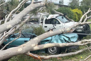
The clean-up continues in the south-east, with rain easing after flooding hit the region hard, particularly the Moreton Bay area north of Brisbane.
But there may be more heavy showers to come after a low formed off Queensland’s south-east coast.
It is a “low” chance of intensifying into a cyclone by mid-next week but may then track back towards the Queensland coast, the Bureau of Meteorology said.
-AAP