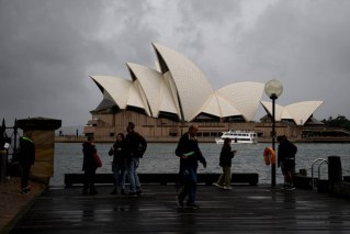
Sydney sets wettest year on record
Source: Bureau of Meteorology
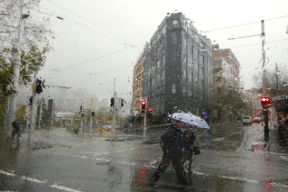
Sydney is in the midst of its wettest year on record as widespread drenching rain puts many parts of western NSW on flood alert.
The previous annual record of 2194 millimetres of rain, which had stood since 1950, was broken at 12.30pm on Thursday after 27.2 millimetres of rain at Sydney’s Observatory Hill Bureau of Meteorology station from 9am.
The bulk of the rain fell in about 90 minutes, beginning at 11am.
“We’ve seen a lot of rain around Sydney today, but it is only going to get worse,” NSW Emergency Services Minister Steph Cooke said on Thursday.
“Saturday is likely to be our danger day for Sydney and surrounding areas. We know that our catchments are saturated, the dams are full and our rivers are already swollen so, any extra rainfall, no matter how minor, is likely to exacerbate existing flooding circumstances.”
With nearly three months remaining in 2022 and the declaration of a third consecutive La Niña by the BOM in September, more rain is expected to fall before the end of the year, further inflating the record.
Sydney had its wettest July on record this year after only two weeks, passing the 1950 record of 336.1 millimetres on the way to a total of 404 millimetres.
March broke a 1942 record of 521.4 millimetres when 554 millimetres fell.
Tweet from @weatherzone
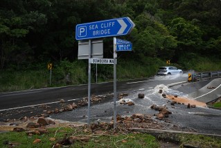
The ongoing deluge will mean rivers on and west of the Great Dividing Range are hit by moderate to major flooding, affecting towns including Tamworth, Dubbo and Bathurst.
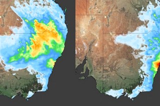
Forecaster Weatherzone said this week’s rain was caused by low-pressure troughs that brought about a month’s rain to parts of inland NSW, Queensland, Victoria and South Australia. This week had also brought:
- Bourke’s wettest October day in 67 years;
- the largest October daily rainfall total in 37 years for Lake Cargelligo in NSW;
- 51.2 millimetres in 24 hours at Camden in Sydney’s south-west – its wettest October day in 23 years;
- While not quite as heavy in Victoria, every single rain gauge across the state has recorded rainfall.
There remains a severe weather warning for heavy rain and thunderstorms across inland NSW, with no reprieve in sight this week.
Much of the state can expect showers and thunderstorms on Thursday afternoon, with the south-west forecast to have severe storms, heavy rainfall, possible hail and damaging winds.
There were more than 40 active warnings, with particular concerns about flooding in the communities of Forbes, Warren, Dubbo, Nyngan and Bathurst, SES assistant commander Sean Kearns said.
“We are also watching this weather system as it may move across metropolitan areas on the east coast,” he told Nine’s Today program.
Ms Cooke said flood threats across NSW had more than 500 SES volunteers in the field.
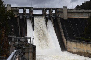
“Our landscapes are entirely saturated, our dams are basically full and the river systems, those channels, are also full,” she said.
Tweet from @weatherzone
By Thursday afternoon, there had been more than 240 calls for assistance and four flood rescues in NSW in the previous 24 hours.
Farmers are also concerned the latest deluge will destroy another crop and graziers have been warned to to shelter stock from the wind and rain.
“There is a risk of losses of lambs and sheep exposed to these conditions,” the BOM said.
Many NSW towns are dealing with renewed flooding, including Warren, where there is again major flooding on the Macquarie River.
“It hasn’t been hammering with rain, but we have had such a lot of rain consistently, basically since Christmas, that it just doesn’t have a chance to dry out,” Macquarie Caravan Park owner Carolyn Monkley said.
“Rainfall here is totally different to rainfall on the coast. A couple of inches out here makes it very very … soggy.”
Other towns of concern include Condobolin, Nyngan, Cobar, Bourke, Wanaaring and Brewarrina.
Flood warnings are current across inland catchments including the Namoi, Macquarie, Bogan, Lachlan, Murrumbidgee, Murray, Edward, Culgoa, Birrie, Bokhara, Warrego, Paroo, Barwon, Darling, Macintyre and Snowy rivers.
Minor flooding is predicted on Thursday in western Sydney’s Hawkesbury-Nepean region.
Coastal catchments including the Hunter, Hawkesbury and Colo rivers, and Wollombi Brook, are being monitored with rises expected.
More rain to come
Weatherzone warned that this week’s big wet is not over yet, wtih another cold front sweeping across Australia’s east.
“Overall, widespread falls of 20-50 millimetres with isolated pockets of more than 100 millimetres are expected over the next four days over southern Queensland, NSW, Victoria and northern Tasmania,” it said.
Friday is expected to be the “biggest day” of the week, with widespread rain, severe thunderstorms and flooding.
“Severe thunderstorms should be widespread in the afternoon, with heavy rainfall, large hail and damaging winds all on the cards through western Queensland, NSW and Victoria,” Weatherzone said.
“Widespread falls of 10-30 millimetres are expected, but quite a few heavier patches of 60-100 millimetres will come along with storms.”
-with AAP