Flood alert for northern NSW as thunderstorms close in
Source: Bureau of Meteorology
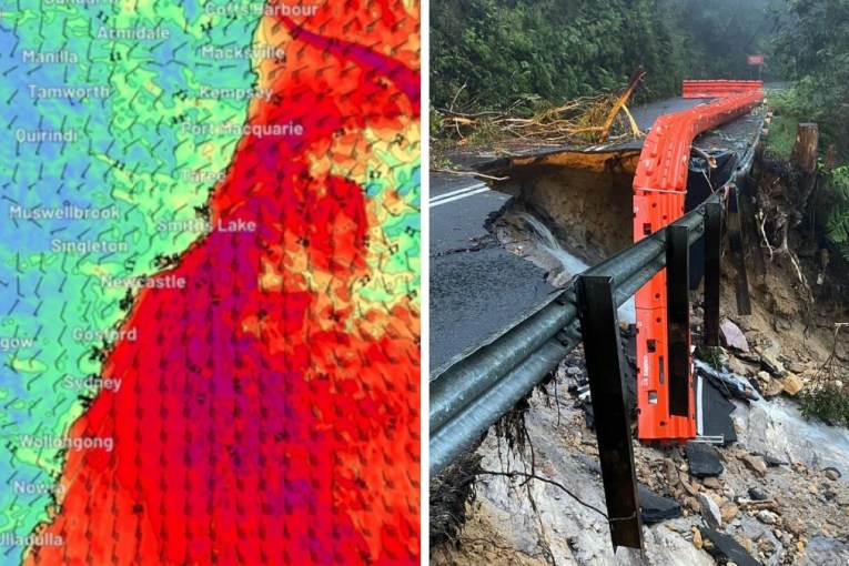
Parts of northern NSW are braced for a third bout of flooding this year, as a band of bad weather continues to pose a flooding risk across large parts of the state, with active weather warnings inland and through to the coast.
Heavy rain forecast for later on Thursday and into Friday could spark flash flooding on the mid-north coast and northern rivers, the weather bureau warned.
Lismore, Grafton, Taree and Coffs Harbour – where catchments are already soaked – are among the areas expected to be affected.
“A severe weather warning for heavy rainfall is current for the northern rivers and parts of the mid-north Coast with 24-hourly totals of 80 to 120 millimetres expected, and isolated falls of 200 millimetres possible,” the Bureau of Meteorology said in a statement on Thursday.
“The situation is evolving and the bureau is monitoring the rainfall closely.”
It has already issued a minor to moderate flood warning for Wilsons River in Lismore, with peaks above moderate possible from Friday and into the weekend.
Tweet from @BOM_NSW
Thunderstorms are likely to develop in the area on Thursday afternoon, bringing heavy localised rainfall.
Forecaster Weatherzone described the system as a “dynamic weather set-up” that had already brought frequent thunderstorms to central and eastern Australia.
“As the system moves further east on Thursday, dangerous storms and heavy rain will also spread over parts of north-east NSW and south-east Queensland,” it said.
An area of persistently heavy rain and embedded thunderstorms will develop over north-east NSW on Thursday into Friday morning as a low pressure system forms near the coast.”
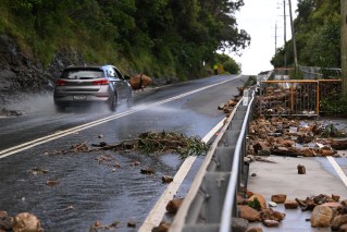
The SES has warned residents and people travelling across NSW to monitor the weather and road conditions and avoid unnecessary trips.
“With heavy traffic expected over the coming days, we can expect unfavourable conditions to cause extra hazards to road users,” NSW SES superintendent Joanna Jones said on Thursday.
The SES has spent the week preparing, with assets deployed to the mid-north coast near Port Macquarie and work around Casino and the northern rivers to respond to the evolving situation.
The service reminded not to enter floodwaters after it conducted two rescues on the Coffs Coast.
There were also multiple rescues in Warren, west of Dubbo, where major flooding on the Macquarie River is forecast to continue for several days.
People have been rescued from vehicles submerged in floodwaters on Ellengerah Road, which runs alongside the river.
The town is protected with a levee, although it has deteriorated in recent years.
The local council was awarded a $5.3 million federal grant to begin rehabilitation works in May.
The threat of further flooding comes after severe thunderstorms with large hail, heavy rain and damaging winds hit inland NSW and southern Queensland on Wednesday.
Flooding affected the inland towns of Dubbo, Gunnedah and Tamworth on Wednesday afternoon and major flood levels were reached on the Lachlan, Narran and Macquarie rivers, Ms Sturrock said.
Helicopters prepared to deliver supplies to the town of Wee Waa, between Narrabri and Walgett, as flooding cut the Kamilaroi Highway in both directions.
Bureau of Meteorology senior meteorologist Jenny Sturrock said light to moderate falls across saturated catchments had the potential to trigger significant flood responses.
She urged the community to stay up to date with warnings from the BOM.
Wee Waa is already experiencing major flooding, with water levels expected to rise further on Thursday.
Moderate flooding is also expected along the Peel River in Tamworth.
-with AAP