Record downpours to bring new flood risks to Qld, NSW
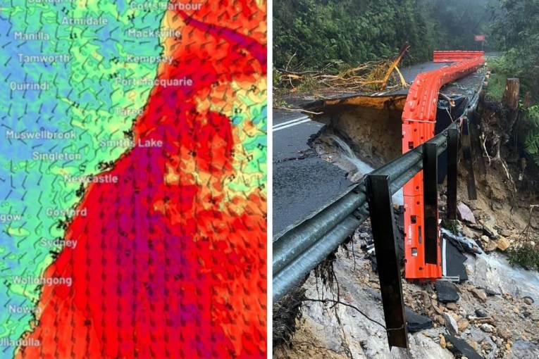
Record rainfall is likely to bring more flooding to Queensland and parts of NSW this week, with authorities urging people to avoid unnecessary travel as the deluge begins.
The weather bureau issued a severe weather warning for Queensland’s central-west and north-west on Monday, with rain forecast along a 700-kilometre stretch from Townsville to Rockhampton and inland to Longreach and Winton.
The Bureau of Meteorology said six-hour rainfall totals of up to 100 millimetres were likely, and up to 150 millimetres could hit some parts of the state’s central-west.
“Locally intense rainfall with embedded thunderstorms, which may lead to dangerous and life-threatening flash flooding, is also possible for the central-west and parts of the north-west districts,” it said.
The weather bureau has put more than 30 rivers and creeks on flood watch, including all of those flowing into the Gulf of Carpentaria, the Lake Eyre Basin, as well most of those between Townsville and Cairns.
It said many of those catchments were already saturated from the Anzac weekend floods, with some still flooding.
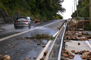
“This rainfall is also expected to lead to transport disruption,” the BoM said.
Townsville Mayor Jenny Hill has put residents, particularly in the city’s north, on alert with 150-200 millimetres rain forecast on Wednesday.
That’s up six times the area’s monthly average in one day, and Cr Hill said low-lying areas faced the risk of flash flooding.
“The concern we have, where we might see high intense rainfalls in less than two hours, the catchments are quite damp,” Cs Hill said.
“We are likely to see flash flooding, particularly around our northern beaches, around the Bohle and Black River areas.”
“It’s areas that we don’t have any weirs or ability to regulate how the catchment operates that the community could be at risk.”
The BOM also warned that rain was on the way for flood-hit regions in northern NSW from later on Tuesday. It will spread south and east on Wednesday and Thursday.
The bureau has already issues a warning for minor flooding on the Bogan river. There was also minor flooding at Dandaloo on Monday, with Mudall also likely to be affected later in the day.
“Get ready, NSW, for some further wet weather. Prepare now,” the NSW SES tweeted on Monday.
Tweet from @BOM_NSW
In Queensland, police have warned against unnecessary travel, including for holidays or work, once the rain begins from Tuesday.
Acting Inspector Donna Stewart said one in 10 road deaths in the state this year were from people driving in flood waters.
“It’s incredibly frustrating to see the number of people who aren’t heeding our warnings,” she said on Sunday.
During the worst of the weather, areas on Queensland’s central coast can expect up to 300 millimetres of rain within six hours, along with damaging winds.
“There’s going to be widespread rainfall basically across the entirety of the state,” Bureau of Meteorology senior meteorologist Felim Hannify said.
“The real event starts to ramp up particularly from Tuesday to Wednesday.”
Mr Hannify warned parts of Queensland were already saturated and flooding presented a threat to lives and livestock.
He said the severe weather would be fuelled by two troughs, one coming from the interior and another from the north coast.
Later in the week, the rain is also expected to push south into Victoria. The BOM said patchy rain was expected to extend into the state from late Wednesday and spread across most of Victoria on Thursday and Friday.
-with AAP