Queensland braces for record temperatures as early summer heatwave intensifies
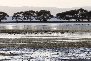
The sun rises over the Gold Coast on Wednesday morning – and the day is going to be warm.
Heat records could tumble on Wednesday as sweltering conditions intensify in parts of southern Queensland, the Bureau of Meteorology says.
A trough system that brought scorching temperatures to south-west Queensland in the past few days has arrived in the Maranoa and Warrego and Darling Downs and Granite Belt.
BOM senior forecaster Felim Hanniffy said several locations would approach December records after Queensland’s second-warmest November.
The mercury is forecast to hit 46 degrees in Goondiwindi, 44 degrees in St George, 41 in Dalby and 37 in Toowoomba.
“Inland, you’re looking at eight-11 degrees above average and even the overnight minimums could be eight-10 degrees above average,” Mr Hanniffy said.
“Most of the Darling Downs is 10 to 11 degrees above average.”
South-east Queensland will feel the heat too, with Brisbane to peak on 34 degrees, Ipswich 40 and a blistering 42 forecast for Gatton.
Mr Hanniffy said the trough system would edge slightly east on Thursday.
“It’s not going very far in a hurry though … it’s just going to stall there but it could bring some localised thunderstorms and some locally heavy falls about the Granite Belt,” he said.
“To the west of it, over in the far south-west and Maranoa, it’ll be a little bit cooler but still well above average for the time of year.
“Temperatures, even on Thursday, will still be in the low 40s.”
Tweet from @BOM_Qld
Goondiwindi Regional Mayor Lawrence Springborg said despite the run of days above 40 degrees, locals were coping with the conditions.
“People don’t like [the heat] a lot but people in rural areas tend to deal with the heat and the reality of those things in their everyday life,” he said.
“Working in temperatures over 40 degrees is something a lot of people do.
“Of course, the big issue now is we’d love to see some rain and, hopefully, that’s something that’s going to happen in the not-too-distant future.”
Mr Hanniffy said it would not be until the weekend when another system developed in south-west Queensland late on Saturday that temperatures should ease.
“That system looks like the significant system that will flush out all this very warm and muggy weather,” he said.
“Later in the weekend, and early next week, it’ll bring a change back to cooler conditions across parts of the south as well.
“If you look at, for instance Birdsville and these areas, temperatures [will be] dropping back to the low 30s by about Monday and temperatures could be as much as 15 degrees cooler than what we’re seeing at the moment.”
Tweet from @BOM_Qld
Queensland Fire and Emergency Services have imposed a local fire ban until 11.59pm on December 7 for the Logan, Scenic Rim, Ipswich, Lockyer Valley, Somerset and Gold Coast local government areas.
Last month was Queensland’s second-warmest November on record.
November 2014 was the warmest.
Maximum temperatures last month were 2.85 degrees above average, the minimum was 2.17 degrees above and the mean temperature 2.51 degrees above.
Birdsville, in the state’s far south-west, had a November-record run of four days above 46 degrees, peaking at 47.1 on Monday.