May kicks off with no end to wintry chill across Australia’s south-east
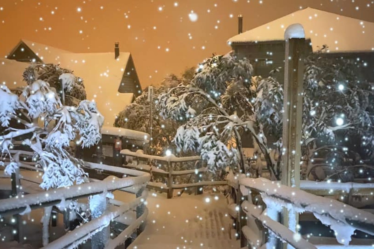
A snowy scene at Victoria's Mount Hotham on Thursday. Photo: Facebook/Hotham Alpine Resort
Victorians are enduring a cold and rainy Friday, with Melbourne likely to have its coldest May day in half a century.
The city was forecast to hit a top of just 12 degrees on Friday, amid another day of wet weather, wild wind and even snow across the state.
That would be its coldest May day in 50 years.
“With the wind around we are expecting ‘feels like temperatures to generally be in the single-digits right across the state,” bureau forecaster Tom Delamont told radio 3AW.
“Even in Melbourne, the ‘feels like’ is likely to be closer to 7 degrees.”
Bureau of Meteorology extreme weather meteorologist Dean Narramore said Friday has been one of the coldest days Victoria has experienced “in a long time”.
“Severe weather is continuing right across the state as temperatures are anywhere from five to 10 degrees below average,” he told reporters.
Rain that lashed Victoria on Thursday continued into Friday, with Melbourne already having more rain in the first four months of 2020 than it got for all of 2019.
The inner-city Olympic Park weather station recorded 374.4 millimetres of rain in 2019. By the end of April 2020, it had had 400.8 millimetres.
It was the city’s wettest April since 1960, with more than 138 millimetres of rain.
In the 24 hours to 9am on Friday, Melbourne’s east had 8 millimetres of rain – on top of the 40 millimetres in the same period to 9am Thursday. In the south-east, the figures were 15 millimetres to 9am Friday, after 40 millimetres for Thursday.
The chill delivered snow to the state’s ski resorts. Falls Creek, Mount Buller and Mount Hotham were expecting as much as 50 centimetres by Saturday as the temperature fell below zero.
The cold and rain will persist across the state for several days, with the wind making it even feel colder, especially in Melbourne and along the coast.
No relief for NSW
Sydney and Canberra haven’t escaped the late-autumn blast, with Canberra expecting a top of just 8 degrees on Friday.
Snow has also fallen in NSW, and the weather bureau said parts of the state would have their first frosts this weekend.
The Bureau of Meteorology expected maximum temperatures in the single digits and mid-teens on Friday, with gusty westerly winds.
Meteorologist Helen Kirkup said the Snowy Mountains region could expect about 80 millimetres of rain on Friday.
About one metre of snow fell over the Alpine region with another metre expected overnight on Friday.
Ms Kirkup said cold temperatures in Sydney would continue into the weekend but the rain should clear on Saturday.
But Ms Kirkup doesn’t expect May records to be broken at this stage.
“The coldest air has come through so tomorrow will be slightly warmer and the cloud cover will move off by Sunday,” the meteorologist said.
“We’re going to see this front moving out into the Tasman and behind that we’ll see a high-pressure ridge start to strengthen across the region,” she said in a video shared by the bureau.
“With the skies clearing and this cold air mass, the night-time temperatures are going to start dropping so that we will see frost developing by Saturday night.”
The highest rainfall over the past 24 hours until 9am on Friday was in Kars Springs in the Hunter region with 44 millimetres followed by Nundle, south of Tamworth, which recorded 37mm.
Ms Kirkup said a cold front moving to the southeast caused 93km/h wind gusts through the Blue Mountains region before 11am on Friday.
Frost is predicted for Sunday night and into early Monday morning throughout the Northern Tablelands and down into the South West Slopes, she added.
“It’s certainly cold enough and there’s a fair bit of moisture around.”
Coonamble (13.9 degrees), Wellington (13) and Nowra (13.8) all reported their coldest April day on record on Thursday.
Tweet from @BOM_ACT
Chill in the Sunshine state
Queensland hasn’t escaped the chill, with record low temperatures in the outback on Friday.
Applethorpe on the Southern Downs had a chilly start to the day, with the mercury falling to 5.1 degrees.
Brisbane and Ipswich were forecast to get to 24 and 25 degrees – “a good five degrees cooler than [Thursday]”, BOM senior forecaster Shane Kennedy said.
In outback Queensland, Thargomindah broke the 1989 record for the coldest April day on Thursday, with a maximum of just 18.5 degrees.
Birdsville also beat its 2015 record with a 20.6 degree day, and the Ballera Gas Fields had its coldest April day, with 18.9, since monitoring began there 18 years ago.
Granite Belt Wine and Tourism president Martin Cooper said it was “bloody cold” when he started work in his vineyard on Friday.
“I knew it was cold because the dogs just looked at me when I said, ‘Come on, get out’ – they just went back in front of the wood fire,” he told the ABC.
Mr Kennedy said skies should remain clear but cold winds would continue in the south-east.
“Starting from Monday, the winds will start to turn a little bit more easterly and start to slowly bring some moisture back,” he said.
BOM forecaster Kimba Wong said the Sunshine Coast hinterland was expected to fall as low as 6 degrees on Saturday, and coastal areas such as Maroochydore to 8 degrees.
Tweet from @BOM_Tas
-with agencies