Pre-summer heatwave brings scorching – and dangerous – weather
Thousands will be sweating across Australia as a pre-summer heatwave strikes. Photo: AAP
A blast of pre-summer heat has hit Australia’s east and south-east, bringing soaring temperatures into the low 40s and fire bans for two states.
There are also fears the cool change that will follow will bring thunderstorms that could spark fires, and dangerous winds.
Sydney is forecast to hit a relatively mild 27 degrees on Thursday, but 35 is expected on Friday.
Residents of the city’s west, however, can expect to sweat – 33 degrees is forecast for Penrith on Thursday, and 37 on Friday.
Melbourne is likely to reach 34 degrees on Thursday – 14 degrees above its October average – before a cool change brings a relatively mild 24 on Friday.
Thursday’s heat has also brought Victoria’s first fire danger warning of the season. Fresh, gusty winds have prompted the weather bureau to declare Thursday a day of severe fire danger in the Mallee, in the state’s north-west.
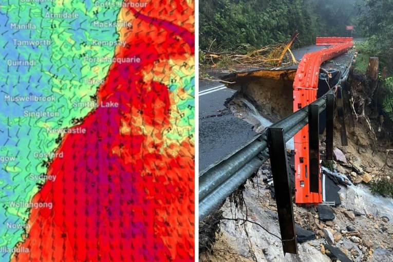
Hot, dry & windy conditions over coming days will increase fire activity on Carrai Crk Fire & the Jacobs Spur Fire west of Kempsey. People in the areas from Lower Creek to Bellbrook, to Willawarrin & Moparrabah, Toorumbee & the surrounding areas should monitor conditions #NSWRFS pic.twitter.com/HMOHrovwzR
— NSW RFS (@NSWRFS) October 23, 2019
Warm, windy days ahead for #NSW. Temps increase across the state from Wed, some parts more than 12C above average. Western Sydney may hit 37C on Friday, before a cold front brings cool change for the w/end. N/E will experience last of the #heat on Sat. https://t.co/iNWG97bSNT pic.twitter.com/RPXlyjwbOY
— Bureau of Meteorology, New South Wales (@BOM_NSW) October 22, 2019
ABC weather presenter Graham Creed said the cool change would bring thunderstorm activity as it moved through South Australia and western NSW.
“We are not expecting to see rainfall unless you are directly underneath one of these thunderstorms, and because there is not a huge amount of rainfall, some of the lightning strikes may actually start fires across the
region,” he said in a Thursday afternoon update.
“As the front moves through … a very gusty south-westerly wind change moving behind in the heat will build throughout New South Wales ahead of the trough.”
South Australia is expected to bear the brunt of the pre-summer heatwave, with fire bans declared in 10 districts on Thursday.
Across the state, highs of 41 degrees were expected at Coober Pedy and Port Augusta on Thursday. Whyalla and Port Pirie should reach 39 degrees.
Adelaide residents could expect the city to hit 36 degrees on Thursday. They are also being warned of wind, dust and significant fire danger.
CFS state duty commander Yvette Dowling said the public should be mindful of the potentially dangerous conditions.
Farmers harvesting crops also should monitor local weather conditions and stop work when conditions worsen, she said.
Reminder: Total Fire Bans have been declared for Thursday 24 October 2019 in the following Fire Ban Districts:
Northwest Pastoral, West Coast, Eastern Eyre Peninsula, Lower Eyre Peninsula, Flinders, Mid North, Mount Lofty Ranges, Yorke Peninsula, Kangaroo Island, Lower South East pic.twitter.com/RRLTN0wz1t— Country Fire Service (@CFSAlerts) October 23, 2019
Bureau of Meteorology forecaster Mika Peace said the cool change would sweep across South Australia late on Thursday – bringing temperatures about 20 degrees cooler on Friday.
“We are forecasting hot and windy conditions before the change, and strong winds following it so if a fire has started, it will move quickly,” she said.
Elsewhere:
Canberra: A top of 31 on Thursday, with 29 forecast for Friday. North-westerly winds strengthening on Friday as the cool change nears.
Brisbane: Beautiful one day, perfect the next, with tops of 28 degrees on Thursday and Friday. The chance of a thunderstorm … but not until Saturday.
Hobart: 27 degrees on Thursday and a windy 24 degrees on Friday. Showers forecast for the weekend.
-with AAP