Antarctic air blasts bring a dose of winter to SE Australia
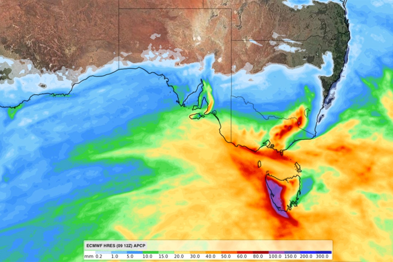
A prediction for where the most rain will fall between Wednesday and Sunday night. Photo: Weatherzone
A trio of cold fronts is about to deliver a hefty dose of winter – including snow and dangerous winds – to Australia’s southern states.
The Antarctic air blasts will roll across South Australia, Victoria, NSW, the ACT and Tasmania in the next few days, bringing snowfalls to as low as 900 metres and gale force winds.
South Australia will the first to bear the brunt of the cold snap, with first front rolling in on Wednesday. It will cross the border into Victoria by Wednesday afternoon.
A second, more powerful, system will arrive in the south-east on Friday, before one more winter blast to round off the weekend. Tasmania will feel the full force of the final front on Sunday.
Potentially damaging winds heading towards #Victoria, likely to reach #Melbourne from around 6pm. It's associated with the passage of a strong cold front @vicsesnews. Keep up to date with the latest warnings: https://t.co/SRb93fXzZm pic.twitter.com/ydv20buOOg
— Bureau of Meteorology, Victoria (@BOM_Vic) July 10, 2019
The weather bureau is predicting up to 50 millimetres of rain on the mainland and up to 150 millimetres in western Tasmania, which will feel the full force of the triple whammy of bad weather.
“A cold front will move over Victoria today, reaching the west of the state mid-late afternoon, central parts in the evening and clearing the east Thursday morning,” the Bureau of Meteorology said on Wednesday.
It warned residents to expect winds of 60-70km/h, with peak gusts of 90-100km/h above 800 metres.
“Locally destructive winds with peak gusts of 130km/h and blizzard conditions are possible about the Alpine peaks in eastern Victoria from Wednesday evening, until early Thursday morning.”
Maximum temperatures across Victoria will be mostly 11-15 degrees. Notable exceptions include Ballarat and Mansfield (maximums of 12 degrees), while high country temperatures are unlikely to rise much beyond freezing.
It will be slightly warmer in much of southern NSW (maximums of about 16 degrees), while the ACT can expect only 11 degrees.
Jump into this link and check out the forecast! There is up to 90cm of snow coming! 👉 https://t.co/hJETSGIYHn 😱❄️ pic.twitter.com/dTbFUYDkGo
— Perisher (@PerisherResort) July 9, 2019
The wider outlook for NSW is also bleak, with the bureau predicting blizzards in alpine areas from Wednesday night.
“Two cold fronts are forecast to cross southern New South Wales over the coming days: one on Thursday morning and a second overnight Friday into Saturday morning,” it said.
“Vigorous north-west to south-westerly winds are expected with these two systems, with winds only easing later Saturday after the passage of the second front.”
NSW residents are also warned of similar high winds, which are likely to continue until Saturday.
The NSW National Parks and Wildlife Service has recommended that back country travel be postponed until conditions improve.
Of course, not everyone is disappointed with the weather forecast.
“This weeks forecast is looking like a treat,” Perisher Ski Resort announced.
“It will get your hearts racing and raring to go to the snow.”
Cold, wet and windy weather is returning to Australia's southeastern states this week thanks to a pair of strong cold fronts: https://t.co/LV1IRoQARs pic.twitter.com/y7Rxr9k34H
— Weatherzone (@weatherzone) July 10, 2019
Tasmania will also feel the wintery blasts, although a warm front on Thursday night will provide some reprieve. Highs of about 15 degrees are expected, and residents are warned of high winds.
Tasmania will get the worst of the coming rain, with minor flood warnings for the north, north-east and north-west river catchments.