The Vanuatu monster starts baring her fangs
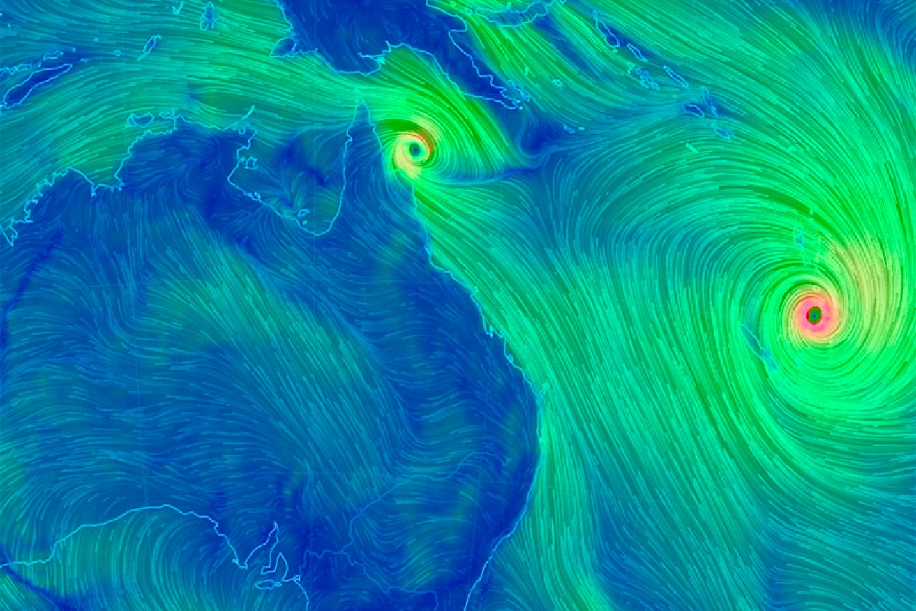
The size of Cyclone Pam can be seen on this wind chart. Photo: ABC
A category five tropical cyclone is battering Vanuatu, packing winds of up to 250km/h and triggering flooding in parts of the country.
The Vanuatu National Disaster Management Office said red alerts were in place for Torba, Sanma, Tafea, Shefa, Malampa and Penama provinces.
• All the latest cyclone updates
The United Nations relief agency says there are unconfirmed reports of several deaths.
The centre of Tropical Cyclone Pam cyclone has passed Port Vila and is moving in a southerly direction at about 25 kilometres per hour.
The island of Erromango took a direct hit as the cyclone tracked south.
Vanuatu’s Meteorological Services said “very destructive hurricane force winds” of 250km/h were affecting Shefa and Tafea provinces.
It warned of torrential rainfalls, flash flooding, landslides and storm surge.
There have been reports the cyclone caused power and water outages in the capital, Port Vila.
Speaking from a hotel shelter, program director for CARE Australia in Vanuatu, Inga Mepham, told ABC’sThe World program that people have heeded warnings to take shelter.
“It’s a thundery noise coming through and obviously things are starting to fly around. We can feel things hitting us at different times,” she said on Friday.
“I think people would still be in disbelief tonight … certainly we are.”
In Fiji, head of the United Nations Office for the Coordination of Humanitarian Affairs (OCHA) for the Pacific, Sune Gudnitz, said the storm was the “worst-case scenario”.
“The most vulnerable will certainly be the people that are living or residing closer to the coastline, which in a place like Vanuatu is a lot of people,” he said.
“Very few structures I think will be able to withstand a category five cyclone of the magnitude that we are seeing.
“So we are looking at potentially total destruction of many shelters, residences, especially in the islands south and outside of Port Vila.”
Vanuatu’s northern islands were the first to feel the destructive force of Pam, the strongest storm to hit the nation of 270,000 people in nearly 30 years.
Aid agencies said many people living in flimsy slum accommodation were particularly at risk, as well as those in remote outlying islands.
Authorities in Vanuatu advised thousands of residents to shelter in evacuation centres ahead of the storm.
UNICEF spokeswoman Alice Clements said the capital resembled a “ghost town” as people battened down.
“The winds have definitely increased, the palm trees are blowing around like crazy, you’re starting to get that kind of howling wind coming through,” the official with the UN children’s agency said.
Meteorologist Neville Koop, from Fiji’s Nadraki Weather Service, said Pam’s winds were capable of bringing down even well-built structures.
He said they could be more destructive than Cyclone Uma, which killed at least 30 people when it sank two ferries off Port Vila.
“Pam has winds which are much stronger than Vanuatu experienced (in 1987)”, he said.
“We are monitoring the humanitarian impact closely and are preparing a potential response to this emergency,” Ms Bishop said.
Earlier, Vanuatu’s meteorological service warned more bad weather was likely to follow Pam as forecast models showed a separate tropical cyclone heading its way.
Cyclone Nathan, a category two storm located off the coast of Queensland, was expected to intensify and possibly hit Vanuatu next week, the service said.
The UN’s OCHA said Papua New Guinea and Solomon Islands could also be affected by Cyclone Nathan.
“This could have devastating effects for communities living in areas that have already experienced prolonged rains and other impacts from Tropical Cyclone Pam,” OCHA said.
The bad weather being generated by Cyclone Pam has been felt right across the region.
In Kiribati, the combination of heavy rain, strong winds and high tides has damaged causeways connecting islets in the most populated area South Tarawa.
The Solomon Islands National Disaster Management Office said it had received reports of damage to houses and food gardens in Temotu province.
Spokesman Brian Tom said high seas were also expected in the Solomons over the weekend, which would delay the ability of disaster assessment teams to reach the affected areas.
ABC/wires


