‘Large to giant hail’ warning as huge thunderstorm band to slam four states
Four states have been warned to brace for storms through to Tuesday — some of which could be “severe” — and the possibility of “large to giant hail” damaging property in Queensland.
The Bureau of Meteorology’s weather update on Thursday forecast widespread showers, rain and thunderstorms across eastern Australia over coming days from Thursday.
The huge band of bad weather will stretch from northern Queensland into New South Wales, northern Victoria and eastern South Australia.
The most “severe” will be on and west of the Great Dividing Range, most likely for eastern inland Queensland and northern inland New South Wales, said the Bureau.
Tweet from @BOM_Qld
“Severe thunderstorms are possible for central and southern NSW and into northern Victoria.
“Some flood-affected areas may be impacted, however, this will depend on where the thunderstorms form and the direction in which they move.”
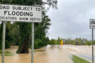
The biggest risk was “heavy rain leading to flash flooding”.
But there was also a possibility of “large to giant hail” and strong winds causing damage to homes and vehicles in inland parts of southern Queensland and inland northern NSW on Thursday.
On Friday, severe thunderstorms will spread across inland areas in NSW, with the possibility of “heavy to locally intense rainfall” over the weekend.
Showers and thunderstorms will spread further south into Victoria and Tasmania, as well as further east towards the Queensland and NSW coasts, including the NSW Northern Rivers where showers will increase further.
Thunderstorms are possible for Melbourne, Sydney and Brisbane.
Over the weekend, showers and storms will move into south-east Queensland, eastern NSW, and showers will increase across South Australia western NSW and western Victoria on Saturday.
During Sunday, a cold front will bring another burst of showers and storms across much of south-east Australia and a low-pressure system is expected to develop over inland NSW on Sunday night, driving further showers and storms on Monday and Tuesday.
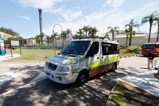
The forecast comes as a woman was rescued from a car in floodwaters in central Queensland, where a town of 500 people has been warned to get ready to evacuate.
Queensland Fire and Emergency Services said the woman in her 20s was rescued after her car became submerged near the flooding Mackenzie River just after 7pm on Wednesday.
She was taken to Emerald Hospital in a stable condition.
In the nearby town of Rubyvale, about 500 residents have been told to prepare to leave for higher ground with catchments already soaked and six-hour rainfall totals of 100 millimetres possible.
Central and southern Queensland are on flood watch as a low pressure system and trough will track slowly eastwards this week.
– AAP