Queensland heatwave smashes November records, Stradbroke Island keeps burning
If you thought summer had started early in Queensland this year, you were right. Temperatures hit the high 30s and into the 40s last month to send records tumbling.
The heatwave that has been gripping the state for the past several days smashed monthly records, with one city – Cairns – sweating through its hottest-ever November day, twice.
The mercury hit a scorching 42 degrees in Cairns two days in a row.
Bureau of Meteorology climatologist Tamika Tihema said it was “significant” to see the record broken in such a way.
“It has never gotten above 42C … but to get two days in a row at that temperature was quite extraordinary,” she said.
BOM said last month was the fourth-warmest November it had recorded on average.
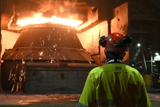
The heatwave has caused trouble for firefighters around the state who are still battling more than 100 bushfires.
Among the other towns to break their November temperature highs was Townsville, which reached 41.7C, beating its previous record of 41C, which was set in 1971.
Innisfail also recorded 41C, compared to 38.8C in November 1992.
Mount Stuart logged the highest temperature across the state for November, reaching 45.2C, on November 26.
Proserpine, Cooktown and Mackay also topped their highest recorded temperatures.
While extreme heat was bearing down on the east, the rainfall across the area was well-below average.
Ms Tihema said it was not the typical conditions they were used to at that time of year.
“You tend to see a lot of onshore flow, so you do see eastern Australia pick up some reasonable rainfall totals, but we saw the opposite this month,” she said.
She said that while Queensland did get showers, they were well below what was expected this time of year.
Deepwater residents return
Meanwhile, a slight change in conditions has seen the fire danger in central and eastern Queensland ease.
The fires at Captain Creek and Lowmead, south west of Agnes Water, have been downgraded to an advice-level warning.
Fire authorities assessed conditions this morning and announced that Deepwater residents, who had been evacuated from their homes for more than a week, could start to return using the southern approach.
More firefighters from Canberra are also headed to Queensland later this week to help with the efforts.
Queen sends special message
Queen Elizabeth II sent a message to Queenslanders affected by the bushfires, saying Prince Philip and her were “saddened to hear of the unprecedented fires impacting so many people in Queensland”.
“I pay tribute to the commitment and dedication of the firefighters, other emergency services personnel, and the volunteers who are working tirelessly to contain the fires,” she said.
“In true Australian spirit, it is heartening to know other states and territories are working alongside Queensland in support of the relief effort.”
A drop in wind and temperature on Monday night helped firefighters battle the bushfire on North Stradbroke Island, which has burned through thousands of hectares.
QFES Inspector Mark Halverson said while the fire was within containment lines, there was still one area of concern near the southern end of the fire.
“The fire is still in the swamp area and it’s fairly inaccessible, so we do have water bombers there attacking the head of the fire. However it’s very difficult to create a containment line there,” Inspector Halverson said.
“There are ground crews working there with rakes and hose creating that sort of a line, and in conjunction with the water bombers we’re fairly confident we’ll be able to contain the fire within that area.”
Cyclone Owen could bring rain
BOM senior forecaster Michelle Berry said there were storms on Monday night to the west of Mackay, where fires were burning, and more rain was coming on Tuesday.
“We are expecting some rainfall for a number of our fire sites [Tuesday] so hopefully that goes some way to alleviating some of the fires that we have for the state at the moment,” she said.
“We could even see some of that activity getting down to the south east tonight over that Stradbroke Island area, where there’s a fire continuing as well.”
Water bombers are so essential for fighting this blaze on North Stradbroke Island – much of the fire is in inaccessible country. #qldfire @abcbrisbane pic.twitter.com/ODriX7kyDN
— Allyson Horn (@allysonhorn) December 3, 2018
Ms Berry said Tropical Cyclone Owen, which is about 1200 kilometres off the coast of Cairns, is expected to weaken from its category one status but could still bring much-needed rain.
“It should weaken into a low or trough and it may move west towards the east tropical and central coast later this week,” she said.
“We may see some heavy falls developing about that east tropical coast in particular through Friday and into the weekend.
“It could be quite heavy if it does move far enough west towards the coast, but if it remains further offshore we won’t get that moisture.”
–ABC
Want to see more stories from The New Daily in your Google search results?
- Click here to set The New Daily as a preferred source.
- Tick the box next to "The New Daily". That's it.


Hanson riles Nationals rivals with surprise move