‘Black nor-easter’ brings rain, storms to NSW, SEQ
Source: Bureau of Meteorology
Heavy downpours, storms and possible flash flooding are forecast to batter Australia’s south-east as dangerous weather phenomenon known as a “black nor’easter” sweeps across multiple states.
Days of heavy rain have polluted dozens of beaches along Melbourne’s Port Phillip Bay, while rainfall totals of more 200 millimetres are forecast for eastern NSW and south-east Queensland from Thursday to Saturday.
The Darling Downs, Granite Belt and Maranoa in Queensland’s south-west are set for showers and possible storms on Wednesday as the weather event intensifies on Thursday bringing widespread, heavy rainfall.
“Widespread shower activity could result in falls between 20 millimetres to 50 millimetres if we do see thunderstorm activity,” the Bureau of Meteorology’s Daniel Hayes said on Wednesday.
Totals could top 100 millimetres in towns such as Charleville, Roma, Dalby, Warwick, Toowoomba and Goondiwindi, extending over to the Gold Coast on Thursday.
Brisbane will not escape the wet weather with potential falls up to 50 millimetres on Thursday.
This could lead to flash flooding for the already saturated areas after months of soaking weather, Hayes warned.
And rainfall totals could be even higher in some places. Forecaster Weatherzone said the combination of a powerful cut-off low and a moisture-rich coastal trough – dubbed a “black nor-easter” – could bring up to 300 millimetres of rain to some areas on Friday and Saturday.
“When a cut-off low and coastal trough interact at the same time, it is often a recipe for heavy rainfall and flooding along the east coast,” Weatherzone said.
“The cold upper air cools down the warmer, saturated air, forcing large amounts of moisture to fall as rain. Similar conditions to these were seen numerous times in 2022, Sydney’s wettest year on record, including in February, March, July and October.
“A black nor’easter gets its name from the darkness of the moisture-rich clouds coming in from the north-east, that can turn the middle of the day as dark as twilight, first dubbed in the early 1800s.”
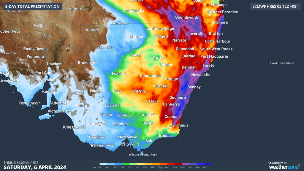
One model of potential rainfall totals by Saturday. Image: Weatherzone
Queensland Premier Steven Miles said the state was still recovering from its most recent floods so the next onslaught of rain heightened the possibility of more river rises, urging residents to be cautious and watch for warnings.
“I assure Queenslanders and the Queensland community that we’re ready for whatever nature throws at us,” he said on Wednesday.
Nor will the wet weather stop there for Queensland, as a trough over the Coral Sea moves towards the north-east of the state on Friday bringing 30-40 millimetres of rain to the Mackay region over the weekend.
As for the rain band pushing south, the NSW State Emergency Service anticipates a flurry of requests for help as the trough soaks the state.
Communities in the New England and Northern Rivers regions, and along the northern half of the NSW mid-north coast, should expect widespread showers of 30-50 millimetres, and up to 100 millimetres in some areas.
The bureau is forecasting the trough will deepen on Friday and potentially develop into a low-end east-coast low, affecting the NSW mid-north coast before shifting to the Hunter, Sydney, Blue Mountains and Illawarra by the evening.
“That may bring damaging winds, heavy rainfall and dangerous surf to much of the coastal area,” bureau meteorologist Sarah Scully said.
The weather system is expected to move south on Saturday to the Illawarra and NSW south coast, bringing heavy rainfall, strong to gale-force winds and hazardous surf.
NSW SES assistant commissioner Sean Keans urged east coast, Blue Mountains and metropolitan Sydney communities to prepare for poor weather by cleaning gutters, trimming trees and branches and securing loose items around homes.
“We still have a few days until the weather may deteriorate, so it’s a good time to make sure you take steps to prepare your homes,” he said.
Emergency assets and crews have been pre-positioned ahead of the forecast wild weather, Keans said.
“Flood and storms teams are on standby to respond should they be required, but we’re pleading with the community to be prepared, stay informed and not drive through floodwaters.”
The warning comes after Melbourne was hit by the equivalent of a month’s rain on Monday. Some parts of Victoria had rainfall not seen for more than 150 years.
-with AAP