More storms and rain forecast after wild Christmas Day
Days of more unpredictable storms and scattered rain are forecast for parts of Australia’s east coast after a wild Christmas Day of hail, record rainfall, floods and intense lightning.
South-east Queenslanders have been told to expect days without power after an intense storm swept through on Christmas night, bringing down 330 powerlines in half an hour — with 160,000 lightning strikes recorded.
Energex said more than 120,000 homes were without power early on Boxing Day in the Gold Coast, Scenic Rim and Logan and it could take days to restore it to some areas.
A woman was killed when a tree fell on her in Helensvale, on the northern end of the Gold Coast.
Most of the tourism strip’s theme parks were temporary closed to clean up the damage including Warner Bros Movie World, Wet’n’Wild, Dreamworld and WhiteWater World.
Tweet from @MrNodus
Australians celebrating Christmas Day in the eastern states experienced extremes of weather — from giant hail to flash flooding.
Golf-ball sized hail rained down on Grenfell, 370 kilometres west of Sydney, carpeting yards in a layer of ice to create a ‘white Christmas’ scene on a summer day.
Ten-centimetre hail was also reported in Orange as scattered severe thunderstorms with damaging winds impacted parts of NSW, such as Dubbo, Orange, Canberra, Yass, Parkes, Wagga Wagga and Albury.
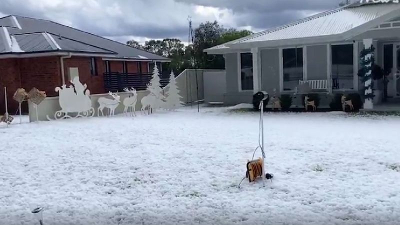
A giant hail storm brought a white Christmas to central-west NSW. Photo: Facebook/Asher Woodrow
Thunderstorms are expected to continue across NSW on Boxing Day, bringing further risk of flash flooding and other damage to large parts of the state.
The Bureau of Meteorology’s Angus Hines said the wet weather would continue for days, including the threat of more severe thunderstorms.
On Christmas Eve a slow-moving severe thunderstorm brought localised flooding to the tarmac at Sydney Airport, causing flight delays, diversions and cancellations and severely disrupting holiday flights.
Weatherzone said the airport received 91.2 millimetres in the 24 hours to 9am Christmas Day, making it the wettest December day in 53 years.
“For what it’s worth, this was also the wettest Christmas Day on record for the station … with records going as far back as 1939 for Sydney Airport,” it said.
Further intense thunderstorm activity was anticipated on Boxing Day as a broad low-pressure trough slowly tracked eastwards, possibly causing further disruptions, Weatherzone said.
In Victoria, Melbourne had one of its wettest Christmases, with record rainfall bringing flash flooding in several regional towns.
Floodwaters inundated homes and covered roads in the town of Wedderburn, north-east of Melbourne, on Christmas Day.
Hundreds of calls for help were made as Melbourne and large parts of Gippsland were on alert for floods.
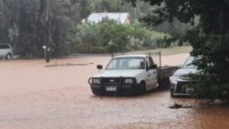
Flash flooding in Wedderburn as Victoria experiences a wet Christmas. Photo: Facebook
More storms in Qld
Queenslanders are also in for more severe weather on Boxing Day, with thunderstorms and rain forecast for large parts of the state.
The bureau said damaging winds, heavy rainfall and large hail were likely between Mackay and the Sunshine Coast, and possible south of Charters Towers.
Isolated to scattered showers and thunderstorms are also predicted for Tuesday over eastern, northern, and far northern Queensland.
Severe heatwave conditions will continue in the northern interior and northwest, with maximum temperatures above average.
Brisbane is expected to have a maximum temperature of 33 degrees, with showers and the chance of a severe thunderstorm.
Multiple severe thunderstorm alerts were issued on Christmas Day, with residents hunkering down in the north and south of the state amid warnings for hail, torrential rain and flash flooding.
An upper trough will cross southern Queensland over the next few days, increasing the likelihood of showers and thunderstorms in the east.
The trough is expected to weaken from Wednesday, extending into a broad low-pressure area on Thursday and Friday, while a weak ridge extends along the east coast.
Jasper clean-up
In the far north, the clean-up and repairs following ex-tropical cyclone Jasper and severe flooding continue.
Crews around Port Douglas and Mossman have reconnected more than 200 kilometres of water pipelines.
More than 4200 property damage assessments have been completed since Jasper delivered heavy rain and damaging winds.
Twelve homes have been confirmed destroyed, 126 properties are severely damaged and 554 moderately so.
Close to 9000 residents have received financial assistance payments.
Flood warnings remain in place for the Barcoo, Paroo River and Burnett rivers, with a flood watch for parts of the Cape York Peninsula.
People visiting the north in coming days have been advised to plan ahead with some roads still blocked.
“Landslides north of the Daintree River have created at least 2500 truckloads of debris which is yet to be cleared,” Douglas Shire Council acting chief executive Scott Mason said.
“We are encouraging tourists and travellers to take extra care when driving in more rural areas and look out for fallen and loose vegetation.”
Sections of the Captain Cook Highway from Cairns to Mossman continue to be cut off but access is available through Mareeba.
Essential services, including water, are successfully being restored to the majority of the shire.
“We are providing community support at recovery hubs and for people who can’t access them our team is on the phone and online offering advice and support,” Mason said.
-with AAP