‘Island of extreme heat’: Dire weekend outlook for millions
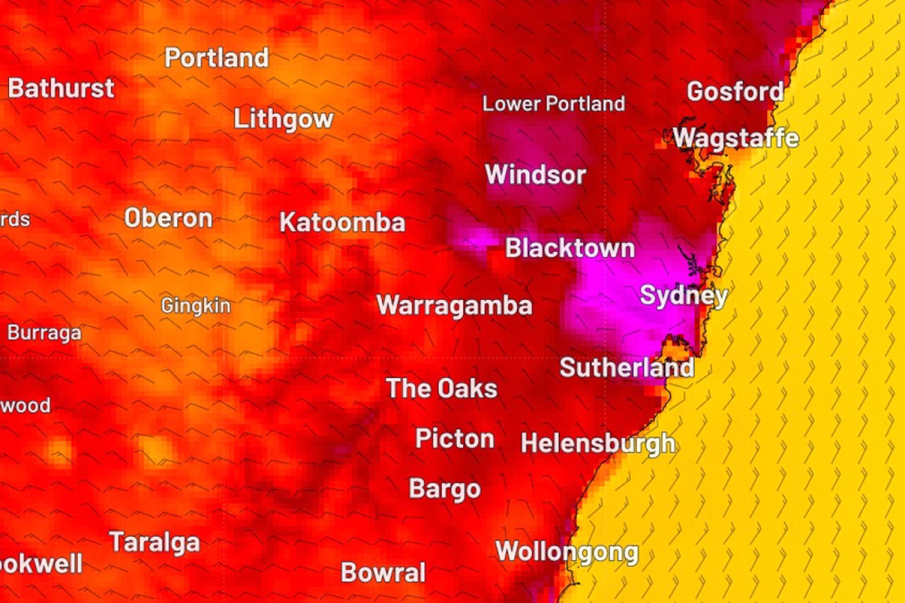
Sydney is set to swelter throughout Saturday. Photo: Weatherzone Image: Weatherzone
Sydney will become an “island of extreme heat” as twin weather patterns supercharge an early-summer heatwave across much of Australia’s east, forecasters warn.
It comes as tens of thousands of people across much of south-eastern Australia swelter through extreme temperatures, with scorching conditions raising fears of bushfires and heat stress, particularly in South Australia.
Further north, Queenslanders are preparing for the impact of Tropical Cyclone Jasper, which intensified to category four early on Friday.
There were heatwave warnings across all mainland states on Friday, with extreme to catastrophic danger for parts of SA, northern Victoria and outback NSW.
And for many Sydneysiders, there will be no relief over the weekend.
“Temperatures are tipped to reach the mid-40s in parts of western Sydney on Saturday as the urban heat island and foehn effects supercharge an early-summer heatwave over eastern NSW,” forecaster Weatherzone said.
The urban heat island effect refers to the ability of built-up urban environments to absorb and emit more heat than natural environments.
The foehn effect refers to a change from wet and cold conditions on one side of a mountain, to warmer and drier conditions on the other (leeward) side.
It will follow a worrying windy and stormy change forecast for later on Friday across much of Australia’s south-east.
“On Saturday, the heat will also push into eastern NSW, with temperatures tipped to reach the high-30s to low-40s in some areas. The mercury could even approach 45 degrees in parts of western Sydney by Saturday afternoon, making it the hottest day since early 2020,” Weatherzone said.
‘Sydney’s eastern suburbs … should top out in the mid-to-high 30s. However, with air likely to be more humid in the eastern suburbs than the western suburbs, the city could still feel hotter than 40 degrees during the afternoon.”
In Adelaide, SA’s Country Fire Service assistant chief officer Cameron Devey said there had been more than 30,000 lightning strikes across the state in the 24 hours to 2pm Friday (local time). Wind gusts of up to 100km/h had also been recorded.
“Dozens of fires have been put out through the hard work and quick response of firefighters,” he said.
“It is only thanks to their absolutely incredible efforts that we are in the position we find ourselves in right now – we haven’t had any major loss or damages occur so far. However, … we have hours and hours to go, and people need to remain vigilant.”
Dozens of schools and preschools closed across SA on Friday, with weather conditions not expected to ease until about 2am Saturday.
“The worst of the weather conditions are forecast in that next four to six hours and then … we will see some moderation,” Devey said.
But the looming change will bring its own risks. Sandbags were being handed out in many SA regions on Friday, with up to 80 millimetres of rain forecast.
Tweet from @7NewsAdelaide
Adelaide hit 29.6 degrees before 7am on Friday, as temperatures across the state headed towards the mid-40s.
Thousands of customers were without power in the early afternoon, mostly in areas east of Port Augusta, as the extreme weather wreaked havoc on electricity networks.
Catastrophic fire danger ratings were declared for the mid-north, Flinders, Yorke Peninsula, Riverland and eastern Eyre Peninsula districts, while five regions face extreme fire danger.
There were also total fire bans for several NSW areas west of the Great Dividing Range on Friday, with more imposed for Saturday. About 20 NSW government schools closed on Friday due to bushfire risk.
“A cool change will flush the heat out of the Sydney Basin late on Saturday, bringing a brief period of relief into next week. However, hot air will linger over western NSW and could spread back over the ranges around the middle of next week,” Weatherzone said.
Tweet from @NSWRFS
Meanwhile, the mercury didn’t dip below 30 degrees overnight in the outback town of Wilcannia as it sweats through a forecast 10-day streak of 40-degree days.
High temperatures sparked a warning to employers to protect their workers and develop a workplace heat-management plan to ensure safety.
“We don’t want to see anyone needing medical attention due to heat exposure,” SafeWork NSW head Trent Curtin said.
“Workers are reminded to listen to their body when the temperature rises and to drink plenty of water.
“It is vital you do not replace water with soft drinks, energy drinks or coffee as these can dehydrate you further. ”
Parts of Queensland, Western Australia, the Northern Territory and ACT have also copped soaring temperatures that are expected to intensify over the weekend.
-with AAP