NSW braces for ‘heaviest rain’ on Sunday as premier warns ‘it’s not going to be an easy week’
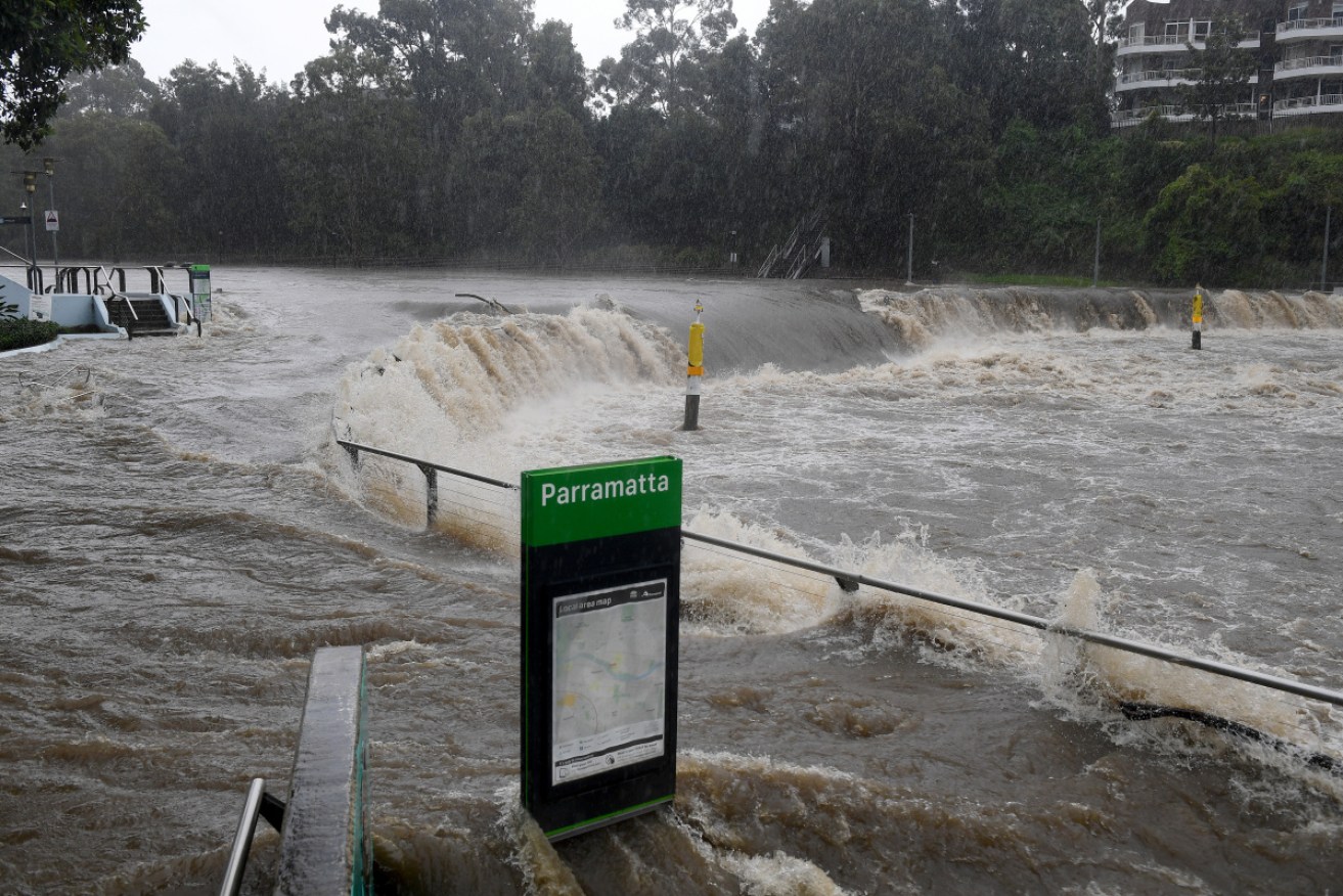
The swollen Parramatta River breaks its banks at the Charles St weir and ferry wharf in Sydney. Photo: AAP
Soaked coastal NSW communities are bracing for an onslaught of heavy rain on Sunday as the weather bureau warned dangerous conditions could continue for days.
Overnight Sunday, people in flood-hit areas were told to leave their homes in the middle of the night as heavy rain kept falling into the morning and rivers overflowed or threatened to flood.
A severe weather warning issued early Sunday forecast very heavy rainfall and flash flooding – that could be life-threatening in some areas – for the Northern Rivers, Mid North Coast, Hunter, Sydney Metropolitan, Illawarra, and Central Tablelands districts.
“Most parts of the warning area will see the heaviest rain during the next 24 hours, however some places may continue to experience periods of heavy rain through to Monday or Tuesday,” said the weather warning issued at 5am.
“The focus of heavy rain in the next 6-12 hours will be the Mid North Coast, Blue Mountains and surrounds including western Sydney, parts of the Northern Rivers and Illawarra districts.”
Highest rainfall totals from Saturday 9am to Sunday 4pm included Stone Quarry Ck Picton 159mm, Oakdale 139mm, Warragamba 120mm and Erina Heights 119mm.
It followed a chaotic Saturday in which emergency crews performed more than 500 flood rescues, a house floated down the Manning River in Taree and a mini tornado left a “trail of destruction” in the Sydney suburb of Chester Hill.
Sydney’s main water source the Warragamba dam started spilling over on Saturday afternoon for the first time since 2016 which caused river levels to rise along the Nepean and Hawkesbury rivers.
Water NSW is also expecting to see spills at Nepean, Cataract, Cordeaux and Avon dams.
Warragamba dam has started to spill. With heavy rainfall persisting, we are also expecting to see spills at Nepean, Cataract, Cordeaux and Avon dams.
For weather forecasts and flood warnings, visit https://t.co/2GW553xMtn
For emergency information, visit https://t.co/7v9ukIZgQB pic.twitter.com/eainGUuCaw— WaterNSW (@WaterNSW) March 20, 2021
The rain and foul weather is being caused by a coastal low-pressure trough combined with a strong high pressure system in the south.
NSW Premier Gladys Berejiklian said weather modelling showed the state could be looking at a one-in-25-year event as she warned “it will not be an easy week”.
“Unfortunately this will be a deep-seated, extreme weather event,” said Ms Berejiklian.
“The rain may not stop till Thursday or Friday.”
“This will be a deep-seated, extreme weather event … It’s not going to be an easy week for us.”
“None of us are out of the woods while the storm front is moving south. The rain may not stop until Thursday or Friday. I hope those predictions are wrong.”

A house and its possessions capsized into the Manning River and Taree. Photo: Screenshot
Overnight evacuations
Residents in the Pitt Town Bottoms, Cornwallis and North Richmond areas west of Sydney were told to evacuate in the early hours as the Hawkesbury River began to flood.
The State Emergency Service issued several orders telling people in these areas to take pets and essential items with them and go to stay with family or friends.
“If you remain in the area, you may become trapped without power, water and other essential services,” the SES told residents in the evacuation orders.

Sandbagging efforts in Penrith, Sydney. Photo: Screenshot
Bellingen residents and people at the Bellinger River Tourist Park area were also told to evacuate because of the risk of flooding.
Evacuation centres were established at Richmond Club and Bellingen Primary School, along with others in the Mid North Coast and Hunter regions.
Flooding was also expected along the Nepean River and the SES urged people in low-lying areas to protect their homes by sandbagging doorways and clearing drains.
Farmers near the Colo River in the Blue Mountains were also told to be on alert for flooding and be ready to move livestock and equipment.
Parts of Port Macquarie, and several nearby towns, have flooded and further south Taree is in the grip of a flood rivalling its worst on record 92 years ago.
“It’s a very dynamic and evolving flood situation,” BOM national flood services manager Justin Robinson said.

NSW Fire and Rescue rescue residents in the Mid North Coast. Photo: Screenshot
A bodyboarder in his 60s went missing off off the coast of Coffs Harbour on Saturday afternoon and crews will resume the search on Sunday morning.
Strong winds have also caused damage, with a small tornado ripping through Chester Hill High School in Sydney’s west, which will remain closed to students on Monday.
Prime Minister Scott Morrison said the scenes across NSW were “absolutely heart-breaking” and the government was ready to assist.
The federal government has announced financial disaster recovery assistance for more than a dozen local government areas.
The COVID-19 vaccine rollout in Sydney and many parts of NSW has been delayed because of the extreme weather, the Department of Health said.
The Public Information and Inquiry Centre provides information about the severe weather at any time of day on 1800 227 228. For emergency help in floodwaters, call the SES on 132 500.
-with AAP