Storm warnings: Queensland set for a soggy end to the Easter break

Queenslanders can likely expect their Monday holiday to be a touch on the damp side. Photo: ABC/Belinda McMahon
Queenslanders might be forced to keep Easter celebrations indoors this year, with severe weather predicted to reach the coast from Sunday.
So far, the weather remains fine across the state, but the Bureau of Meteorology (BOM) said a change was not far off.
Cloudy conditions with isolated showers are expected for the first half of the Easter weekend.
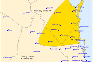
From Sunday through to Tuesday, the BOM is warning there is a risk of heavy rain, damaging winds and hazardous surf for the Capricornia, Wide Bay and South East Coast.
Wind warnings are already in place for waters north of the Sunshine Coast.
Meteorologist Shane Kennedy said Sunday’s weather would first break on the Capricornia and Wide Bay coasts.
He said there could be falls of up to 150 millimetres between Agnes Water to the New South Wales border.
Rain and wind
“You could see daily rainfall totals between 50 to 150mm,” Mr Kennedy said.
“There will be that risk of heavy rainfall [and] potentially, we could see some damaging wind gusts and damaging surf.
“We’re fairly likely to be issuing a severe weather warning for much of south-eastern coastal region.”
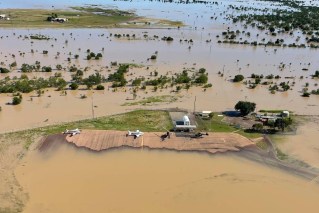
A flood watch is current for catchments between St Lawrence and Byron Bay, in northern New South Wales, after what the bureau called a “wet March”.
The BOM said a deepening low-pressure trough and a developing low was behind it all.
Cloudy conditions down the east coast are forecast for later on Friday, with the chance of thunderstorms developing in north Queensland.
Beach alerts
Meteorologist James Thompson said the east coast had seen “quite a few” showers already on Friday, and Saturday would be similar.
Want more local news?
He said the rainfall could stretch further than the Wide Bay region.
“The Sunshine Coast, Gold Coast [and] Brisbane regions are all in for a chance to see some heavy rainfall,” he said.
“[It] could extend over the ranges into the Darling Downs … and we’re likely to see some showers and storms through central districts.”
The BOM is also predicting hazardous beach conditions.
“For the coastal waters between Fraser Island and over the [NSW] border, we could see some hazardous surf conditions on Monday or Tuesday; maybe even some strong wind warnings,” Mr Thompson said.
More flood warnings possible
The bureau has mapped the weekend’s system to move south, away from Queensland over Tuesday or Wednesday.
Mr Thompson said despite the rain moving away next week, floodwaters could remain, given the “wet March we’ve had, as well as incoming rain”.
He said already a number of Queensland rivers still had “a bit of water moving through them”.
“We saw quite a few flood warnings since March and we could see more flood warnings if we do get this heavy rainfall [on] Monday or Tuesday,” Mr Thompson said.
“Any further rainfall that we do get will just mean those rivers respond really quickly.”
The BOM currently has a flood watch in place for coastal catchments between St Lawrence and the Queensland-New South Wales border, extending inland to the Darling Downs.
–ABC