More wild weather for swamped NSW as rain brings danger to Victoria
Sydney's north have been ordered to evacuate due to flash flooding. Photo: Twitter/Jacqui Kirk
Tens of thousands of NSW residents were without electricity on Monday, with torrential rain expected to bring more heavy flooding and cause rivers to rise to their highest levels in years, perhaps decades.
The devastating storms that brought from strong winds and damaging surf at the weekend are making their way out of eastern NSW and into Victoria’s bushfire-hit regions.
Heavy rain could be enough to help firefighters make gains on fires still burning across Victoria. But the threat of flooding and landslides has authorities worried and firefighters bracing for potential damage to roads across the eastern parts of the state.
In Sydney, police divers are searching for a man who is missing after his car was swept off a causeway into floodwaters at Galston Gorge in the city’s north, the ABC reported.
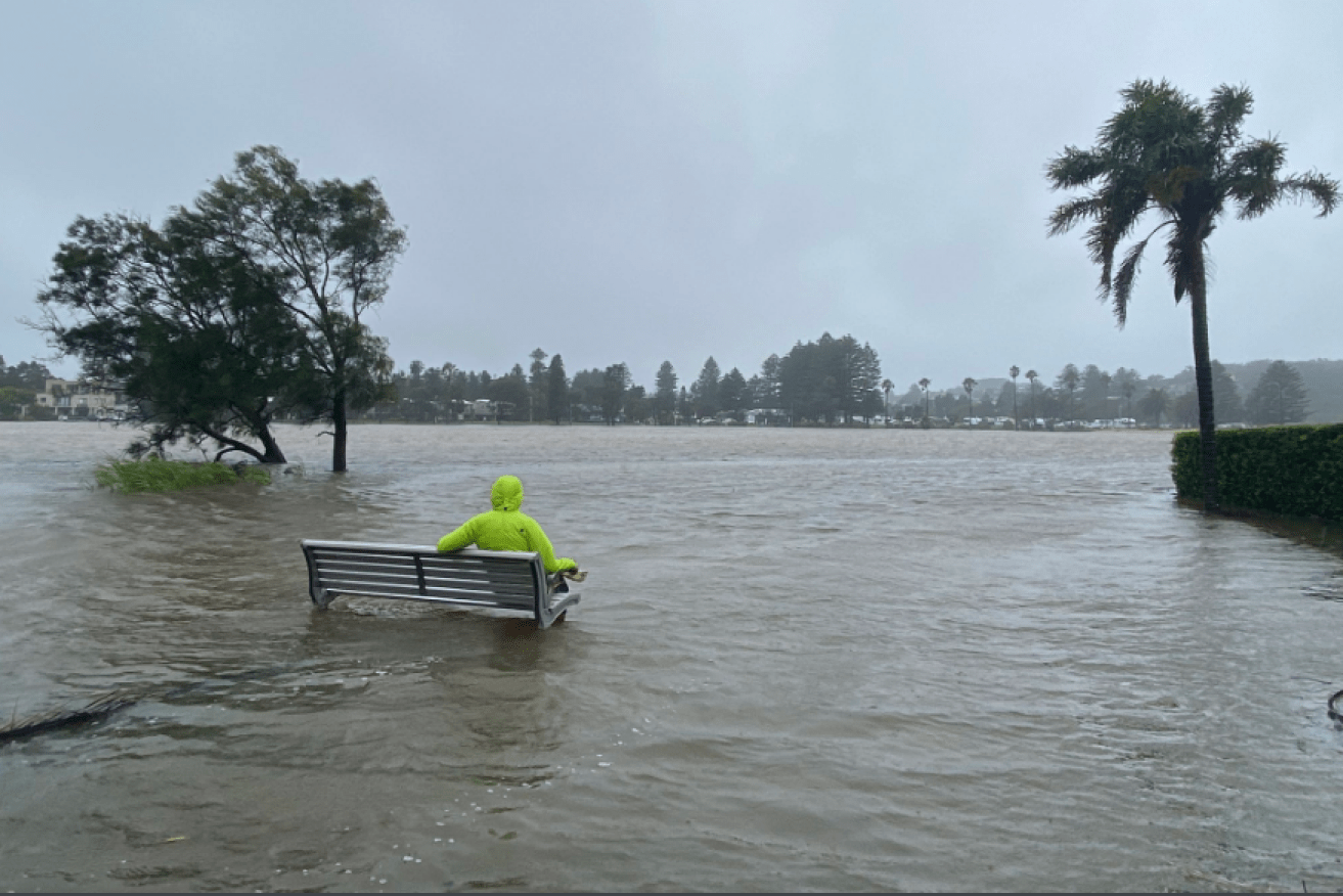
The downpours have been so severe that people are being evacuated from low-lying areas north and south of Sydney because of the threat of life-threatening flash flooding.
Video footage (seen below) taken by Sydney resident Ben Grozier at South Curl Curl Beach shows the impact of strong wind gusts on surf conditions.
The relief the wet weather originally provided was short-lived as the severe weather began wreaking havoc. The SES has responded to about 10,000 calls for help since Friday, and carried out multiple rescues of people trapped by rising rivers and floodwaters.
Images posted to social media show trees fallen onto cars and drivers in heavy traffic, desperate to evacuate.
Elsewhere, power was shut off to at least 134,000 households on Sunday. On Monday morning, utility companies were scrambling to turn the lights back on.
Transport NSW said flooding, blacked-out traffic lights, and road damages had caused closures in inner Sydney, the city’s west and north of NSW.
The Department of Education has shut 54 schools across the state, including at Narrabeen, Picton, Gosford, Wyong, Penrith and Paramatta.
SYDNEY RAIN | Tree down on Danks St Waterloo earlier this morning #sydneystorm #sydneyweather #sydneyrain pic.twitter.com/4V9qqTTeFB
— Ricardo Gonçalves (@BUSINESSricardo) February 9, 2020
Bells line of road traffic at north Richmond #hawkesburyriverflooding pic.twitter.com/1RTc1QYnQS
— Bullant News (@BullantN) February 9, 2020
As well as Sydney, Illawarra and the Central Tablelands were expecting potentially deadly flash floods as torrential rain filled dams and rivers, the Bureau of Meteorology said.
Meteorologist Grace Legg said flood warnings had been issued for significant parts of NSW, including the Hawkesbury, Nepean and Colo rivers.
“Even if the rainfall has eased some of the riverine flooding will continue,” she told The New Daily.
The Georges River at Milperra is on course to reach levels higher than 1988’s flood, while waters near the Narrabeen Lagoon were likely to be worse than the damaging flood of 2016.
Communities along the Hawkesbury and Georges rivers have been ordered to evacuate ahead of surging floodwaters.
The Putty Rd. Blocked by 🔥 & now by 🌧. North Richmond Bridge goes under. Haven’t seen this since I was a boy. It’s healthy for the river and should be allowed to happen more ! #Flooding pic.twitter.com/WewwrdAVhl
— Jonathan Lea (@JonathanLea10) February 9, 2020
Motorists have been urged to heed warnings and stay clear of flooded roads, NSW Emergency Services Minister David Elliott said.
“We have 400 SES volunteers trying to complete the backlog this morning and unfortunately this has included 150 flood rescues,” he said.
“The message to the motorists of Sydney and indeed the wider metropolitan area is if you can avoid being on the roads do so.”
Victoria
There is a severe weather warning for heavy rainfall for most of Victoria, with 25-60 millimetres of rain forecast from early Monday to mid-afternoon.
More than 100 millimetres is possible for areas closest to the NSW border, with the east Gippsland region most at risk, the weather bureau’s Ms Legg said.
“Because of the recent bushfires there, overall the area is a bit more susceptible to flash flooding and potential landslides just because of the lack of vegetation through the area,” she said.
Emergency services have advised that in fire-affected areas, rainfall might bring debris into waterways and trigger landslides and damage roads.
Rain started falling across Victorian fire grounds on Monday, providing some relief to firefighters as they prepare for potential damage to roads in the state’s east.
Emergency Victoria said crews were on standby to clean up and remove hazards from roads. Machinery had been sent to fire-ravaged areas such as Orbost and Genoa.
“Heavy rain should be confined to East Gippsland, which is a double-edged sword,” Emergency Victoria said.
“On the one hand, it’s good bushfire extinguishing rainfall. On the other hand, the vulnerable landscape will be at a higher risk of landslips, trees falling, and pollution of debris and ash running into local waterways.”
Western Australia
Ex-tropical Cyclone Damien, which brought destructive winds of more than 200km/h to the Western Australian coast at the weekend, is expected to weaken as it continues to move inland, tracking south-to-south-east, before eventually losing its cyclone status.
It no longer has gale-force winds, Ms Legg said.
“The system no longer has the intense core that we see in tropical cyclones. It’s basically transitioned to a low-pressure system over land,” she said.
#CycloneDamien happening right now. pic.twitter.com/u3j1zrL95R
— Brad Gandy (@bradgandywa) February 8, 2020
Residents between Dampier and Whim Creek had been warned of the potential for a very dangerous storm tide.
Heavy rain had also been expected to cause flooding in the Pilbara and Gascoyne regions, with falls of up to 300 millimetres or more possible.
Queensland
Showers and possible thunderstorms are forecast for large parts of Queensland following a weekend of downpours.
Showers are also likely in Brisbane on Monday and Tuesday.
The Gold Coast is expected to bear the brunt of the wet weather, including up to 35 millimetres of rain, BOM forecaster Peter Markworth said.
Rain is also forecast for Cape York Peninsula with a monsoon off the coast, while Thursday Island could get up to 70 millimetres on Monday and Tuesday.
Up to 15 millimetres could fall in the town of Stanthorpe, which officially ran out of drinking water in January and had been trucking in water.
“We all have a responsibility to make good decisions on the road to keep other drivers and ourselves safe,” Mr Ryan said.
“But that is especially the case during extreme weather events.”
Mr Ryan said it would be best if residents avoided using roads until the weather cleared.
-with AAP
Want to see more stories from The New Daily in your Google search results?
- Click here to set The New Daily as a preferred source.
- Tick the box next to "The New Daily". That's it.