Weather wrap: Wet and cooler conditions to continue for south-eastern states
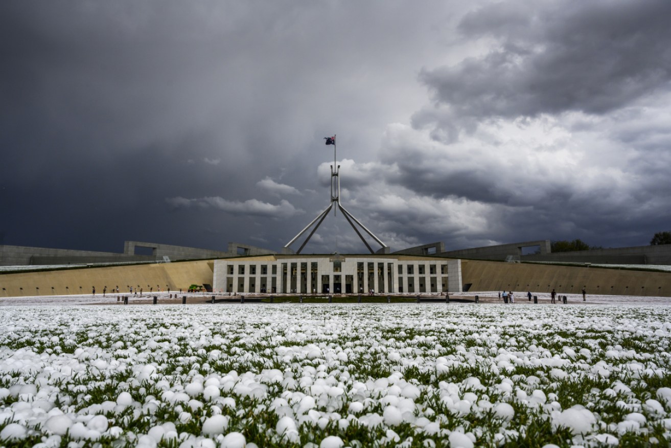
Hailstones the size of golf balls fell at Parliament House at across much of the ACT. Photo: Getty
The wet weather shows no signs of lifting, as heavy rain, winds and hail are set to keep falling across large parts of southern NSW and the ACT, while rain and hail are expected to keep lashing Victoria.
Fierce hailstorms pelted the states over the weekend, where firefighters are still battling active blazes.
In Queensland, massive downpours caused flash flooding in parts of the state at the weekend.
More rain is forecast for south-east Queensland, as water tanks fill in the drought-ravaged state before the hot weather during the week.
Victoria
As 14 mostly advice-level bushfires continue to burn across Victoria, the Bureau of Meteorology has cautioned the entire state to brace for a second day of thunderstorms.
Residents in central and east Victoria can expect anywhere between 10 and 30 millimetres of rain on Monday, but some areas could see isolated totals of up to 100 millimetres, BOM forecaster Dean Narramore told The New Daily.
A number of other regions may experience “20 to 50 millimetres and some locations could see up to 100 millimetres today with any heavy thunderstorms or bands of rain”, he said.
⚠️ Severe Weather Warning updated for heavy rainfall during Monday. Isolated falls of 60-80mm are possible across the warning area and may fall in a short period of time. Peak falls to 100mm are possible in parts of the south. Latest warning: https://t.co/C1wvxHtnm1 pic.twitter.com/AtTI70IfHF
— Bureau of Meteorology, Victoria (@BOM_Vic) January 20, 2020
Emergency Management Victoria Commissioner Andrew Crisp said the weather has helped calm some bushfires in the state’s east.
But it’s too soon to say what impact that will have on firefighting efforts.
“It’s difficult for our firefighters to get onto the firegrounds to better assess what that actually means for us,” he told reporters in Melbourne on Monday.
Despite bringing some relief, the weather has delayed the reopening of a section of the Princes Highway that had been planned for Monday morning.
SES deputy chief officer Alistair Drayton says runoff is also a concern in bushfire-ravaged areas.
“There’s significant chance for runoff today, off the ground, and for those streams and creeks to run quite hard with debris, rocks, sticks and the like,” he told reporters.
There are concerns the heavy rainfall may lead to flash flooding, but the weather bureau says rainfall is unlikely to put out remaining blazes.
Sheep graziers in Gippsland were also warned about the possibility they may lose some stock in these extreme weather conditions.
Areas to be hit by downpours include Bendigo, Shepparton, Seymour, Maryborough, Ballarat, Geelong, Melbourne, Wodonga, Wangaratta, Traralgon and Bairnsdale.
A rescue helicopter clipped a Melbourne powerline on Monday morning but managed to land safely after the incident.
BREAKING: While responding to fire near Kyneton @CommissionerEMV says an air observer helicopter clipped a power line, damage to windscreen – pilot is safe. @10NewsFirstMelb #springst pic.twitter.com/d4w2smAGv0
— Simon Love (@SimoLove) January 20, 2020
Since Sunday morning, Victoria’s SES received 1453 calls for assistance, more than 1000 of them for building damage.
This captures the moment heavy rain turned into a freak hail storm about 2 hours ago: see how it developed: #Periscope: 🇦🇺#VicWeather – developing thunderstorm and rain hit Warrandyte, Victoria, Australia.https://t.co/yyR9Qa0hFo
— Emergency.Life (@Emergency_Life) January 19, 2020
Another 139 callouts were for flooding, while 118 were for trees that had fallen down on roads.
New South Wales
Large hailstones, damaging winds and much-needed heavy rainfall are likely to hit large swathes of southern NSW, with a severe thunderstorm warning issued for the south-west slopes and nearby regions.
“Severe thunderstorms are likely to produce damaging winds, large hailstones and heavy rainfall that may lead to flash flooding in the warning area over the next several hours,” the bureau said just before noon on Monday.
Severe thunderstorms were likely from north of Newcastle to the NSW-Victoria border on the coast.
“Locations which may be affected include Newcastle, Gosford, Sydney, Wollongong, Nowra, Batemans Bay, Orange, Canberra, Goulburn, Dubbo, Wagga Wagga and Albury,” the bureau said.
A severe thunderstorm morning was also issued on Monday for the south-west slopes, as well as parts of the southern tablelands, central-west slopes and plains, Riverina, lower western and Snowy Mountains regions.
Areas likely to be hit by heavy storms included Wagga Wagga, Albury, West Wyalong, Griffith, Narrandera and bushfire-affected Tumbarumba.
Good heavens, the heavens have finally opened here in Wagga Wagga… Rain and now hail hammering down. Send us your farmers in mud puddles videos! 👏 #PRIME7 🌧🌧💧💧☔☔ pic.twitter.com/Edm1Dq4EzI
— Sarah Navin (@SarahNavin) January 19, 2020
The bureau said the low-pressure system prompting the thunderstorm warning would move east to the Tasman Sea on Monday night.
The warnings come as damaging winds from thunderstorms across central NSW on Sunday whipped up dust storms that turned daytime into night.
Videos posted to social media showed dust storms descending on Dubbo and nearby towns that were so thick they blocked out the sun.
A gust of 94 km/h was recorded at Parkes about 6.30pm, while a gust of 107 km/h was recorded at Dubbo about 7.45pm, the BOM said.
Bureau meteorologist Rose Barr said significant rain on Sunday was concentrated across central and northern parts of NSW and east of the ranges.
Many towns on the mid-north coast and in the northern rivers region received between 100 and 180 millimetres from 9am to 10.30pm on Sunday.
ACT
The Australian Capital Territory has been battered by a hailstorm with stones the size of golf balls inflicting severe damage across the national capital.
https://twitter.com/bridgettilley/status/1219071811796627456
The ACT Emergency Services Agency has received more than 620 calls for help after the storm, which lasted about 15 minutes early on Monday afternoon.
The State Emergency Service, Fire and Rescue and Rural Fire Service are responding to hail and roof damage, electrical threats and localised flooding.
ACT Ambulance Service is attending to two people with minor injuries sustained during the storm.
https://twitter.com/Dana_Adele/status/1219074318518243328
More than 1000 homes have lost power, according to the territory’s gas and electricity distributor.
The grounds of Parliament House looked like snow had fallen.
Chaos outside offices in the Parli triangle. Insurance company hotlines will be buzzing. @abccanberra pic.twitter.com/fqoEYKj8dA
— Tom Maddocks (@MaddocksThomas) January 20, 2020
The worst-affected areas are Belconnen in Canberra’s north, the city centre and the inner south.
Car windscreens have been smashed at Old Parliament House, Australian National University and other parts of the city.
Old Parliament House closed to visitors soon after the storm struck.
Queensland
The weather bureau forecasts heatwave conditions across Queensland for much of the week.
The city is expected to reach maximum temperatures in the mid-30s during the week.
But the expected hot weather has been preceded by rain – and lots of it.
Rural residents in drought-stricken areas of the state are celebrating full water tanks from weekend rainfall.
Stanthorpe recorded more than 75 millimetres from Friday, just days after the region officially ran out of water.
Southern Downs Mayor Tracy Dobie said many rural residents in the area had their domestic water tanks filled from the downpour.
There was direct rainfall into the town’s main water supply, Storm King Dam, but a lack of runoff from catchments has kept the dam at near-empty.
But Ms Dobie says any further rainfall would have to be significant to break the drought.
“We need six months’ worth of water to cease water trucking,” Ms Dobie said on Monday.
“The dam received one week’s worth of water, but any more rain could see runoff into the dam.”
She said donations made to the region recently from individuals and corporations have helped residents and businesses survive.
“Some of our people would not have got this far without them,” Ms Dobie said.
Further storms are expected for southeast Queensland after as much as 350 millimetres of rain fell in some areas.
Brisbane is looking at up to 30 millimetres of rain by the day’s end, according to the weather bureau, which also forecasts heatwave conditions across the state for much of the week.
⛈️ FORECAST: Severe thunderstorms possible over #SEQld and the southern tropics today. If they occur, the main risks will be damaging winds and heavy rainfall. Large hail also a possibility near the southern border ranges. Warnings issued as needed at: https://t.co/CinugnxqkN pic.twitter.com/tBmmt2VfUG
— Bureau of Meteorology, Queensland (@BOM_Qld) January 20, 2020
Heavy falls caused flash flooding at the weekend, which shut down major roads and caused delays.
Little Nerang Dam in the Gold Coast hinterland, is near capacity after the downpour.
Seqwater has recorded the dam at 96 per cent full after the weekend rain, up from 72.5 per cent on Friday.
Leslie Harrison Dam near Warwick is almost at 60 per cent according to Seqwater, up from 53.9 per cent.
-with AAP
Want to see more stories from The New Daily in your Google search results?
- Click here to set The New Daily as a preferred source.
- Tick the box next to "The New Daily". That's it.