Deluge over Australia’s east coast dumps ‘dangerous’ torrential rain
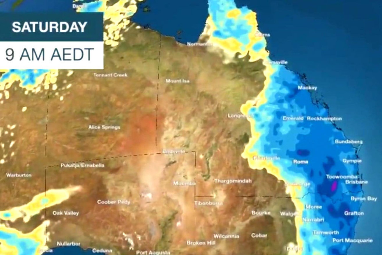
Severe thunderstorms have bought torrential rain to parts of Australia's east coast, with more on the way. Photo: BOM
Parts of Australia’s drought-stricken east coast have copped a thunderous drenching, with ‘dangerous’ rainfall levels cutting highways, flooding homes and cars and forcing theme park closures.
After months of drought and fire dangers, an extreme deluge hit south-east Queensland and northern NSW on Saturday, dumping up to 325mm in a few hours.
According to the Bureau of Meteorology, triple the monthly rainfall has fallen on the Gold Coast in the past 12 hours.
The thunderstorms and heavy rain are expected to continue all the way down the NSW east coast but lessen towards central and southern regions of the state.
Thunderstorm and rainfall warnings were issued for south-east Queensland and northern NSW, with the potential for life-threatening flash-flooding and overflowing waterways.
https://twitter.com/SkyWeatherAUS/status/1218287198077779970
Two people were rescued after trying to drive through floodwater on the Gold Coast, with police receiving more than 50 reports of flooded roads across the city on Saturday morning.
A BOM alert issued at 5am warned about “very dangerous storms” producing “intense rainfall” as major highways were cut and traffic came to a standstill on the M1 Motorway to the Gold Coast.
When Movie World becomes wet n wild… the theme park will be closed today after severe flash flooding. 📸 Michelle Hill. @7NewsBrisbane pic.twitter.com/3QfG1Io4mz
— Mac Lyon (@MacTLyon) January 17, 2020
The weather bureau is predicting a wet weekend for Queensland and NSW, with the battered fire grounds on the NSW South Coast also getting some relief with cooler temps and humid air, albeit much less rain than elsewhere.
“(The NSW south coast) won’t see huge rainfall totals but it does mean the fire danger will be decreased,” BOM NSW meteorologist Katarina Kovacvic told The New Daily.
About half of Queensland is currently drought-declared, including Brisbane, the Gold and Sunshine Coasts, Redland and Moreton Bay council areas.
Most of the NSW coast and central and inland regions are also in “extreme drought”.
The soaking comes as some of the driest parts of NSW celebrated in the wet as rain made a surprise comeback after months – if not years – of horrific conditions.
Towns like Bundarra experienced 105mm in a 24-hour period as farmers raced outdoors to celebrate and feel rain on their faces.
Killabakh on the mid-north coast received the most rain with 98mm falling on Friday while Audley in southern Sydney copped 59mm.
But it was the Gold Coast that was hit hardest, with 325mm of rain falling at Loders Creek and more than 200mm in the Gold Coast Hinterland.
The Australian Reptile Park on the Central Coast was forced to close for the day as a result of the huge deluge.
Overnight drenching
The heavens opened Saturday morning over the south-east Queensland region including Brisbane and the Gold and Sunshine Coasts.
The deluge hit the Gold Coast the hardest with 325mm of rain falling at Loders Creek and more than 200mm in the Gold Coast Hinterland with floodwater closing the M1 at Helensvale – much of it happening in the space of a few hours overnight.
In far north Queensland there were reports of a ferocious storm near Innisfail that caused damage to trees and powerlines.
Gold Coast Rain… My front yard and Street in Labrador 6am today. Sweating and a little nervous right now! pic.twitter.com/phb6GnkAGO
— Parahandy (@VitalSparkCapt) January 17, 2020
Since midnight Friday, the NSW north coast around the Tweed and northern rivers has experienced rainfall of between 10 to 25mm, with some isolated areas receiving as much as 50mm.
Taree welcomed up to 20mm of rain since midnight Friday while the Illawarra region south of Sydney was hit by a line of showers that also delivered about 20mm.
Wet weekend
Heavy rainfall will continue to provide relief to parts of drought-stricken NSW on Saturday after a long period of hot, dry weather and high bushfire risk.
“It will be a showery and wet day over the east of the state, mostly in the north-east…but also Sydney, Newcastle, Woolongong and the Central Coast,” said Ms Kovacvic.
“The south coast is getting some rain but as it makes its way south the rainfall becomes lighter.”
Sydney is expecting more rainfall of up to 50mm after Friday’s falls.
Fire-ravaged regions such as Bega, Batemans Bay, Eurimbula and Eden may experience relieving temperatures in the low 20s but rainfall will be much lower at about 5mm.
Central NSW and the state’s northeast are expected to cop a soaking on Saturday with the potential for heavy rainfall on the north coast and parts of the Central Coast.
Ms Kovacvic said Sunday would be similar to Saturday in NSW and the rain would continue on Monday but over the south-east of the state such as Young, Orange an the Snowy Mountains.
Victoria smoke and fire
Bushfires ripping through Victoria continue to displace residents, with an evacuation notice for some northeastern communities in place overnight.
There were more than a dozen blazes still raging in Victoria on Saturday morning, predominantly in East Gippsland and the northeastern alpine region.
Most were burning at “watch and act” level or lower, but emergency warnings were issued for fires near Mount Buffalo in Victoria’s alpine region, and briefly for Bulart, in the state’s southwest.
Smoke is also expected to return to central Melbourne on Saturday and Sunday as easterly winds cross firegrounds.
Emergency Management Victoria has forecast the air quality will range from good to poor across the state, with areas closest to the fires experiencing the worst haze.
Incident management specialists from the US and Canada are set to arrive at Melbourne Airport on Saturday morning, ahead of being deployed to fires in the northeast and East Gippsland.
-with AAP