Experts give verdict on severity of current drought

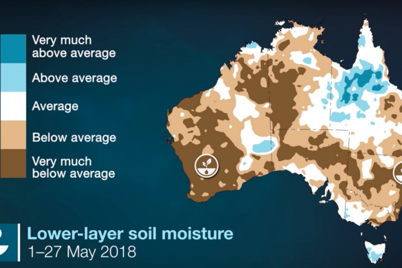
Lower -layer soil moisture was below average across much of the country during May. Photo: BOM
This autumn has been the fourth-warmest on record in Australia, with below-average rainfall for most of the country, according to the Bureau of Meteorology’s autumn summary.
So how bad is the drought and why has it been so dry?
According to Blair Trewin, a senior climatologist at the bureau, the areas experiencing the most significant drought at the moment are in New South Wales, north-west Victoria and eastern South Australia.
“Many parts of central and eastern New South Wales have had well-below-average rainfall, really since April last year,” Dr Trewin said.
“Since the start of this year, the dry conditions have spread to cover most inland parts of the state.”
Rain over the past few weeks in Western Australia has eased drought conditions there although some areas, particularly east of Albany in the state’s south, remain dry.

There are severe rainfall deficiencies across southern Australia. Photo: BOM

A timeline of southern Australia’s autumn rainfall anomalies. Photo: BOM
Dr Trewin said the current conditions were the driest on record over a 14-month period for areas of NSW, including the upper Hunter, parts of the Illawarra and Southern Highlands, and an area in the central-west.
“When you look at the time scale of six months through to a year, it’s a significant [drought] in the worst-affected parts of NSW,” he said.
The only autumn on record drier than this one in southern Australia was in 1902, the year the Federation drought peaked, the Boer War ended, and women got the right to vote in New South Wales and federal elections.
During the Federation drought, the Darling River almost ran dry at Bourke in NSW, and the Australian wheat crop was all but lost.
The current dry is not as extensive as the long-term droughts of the past.
“We certainly don’t have those long-term drought conditions in New South Wales in the way that we had in the 1900s or the 1940s or 2000s,” Dr Trewin said.
“1902 was a very bad year in its own right, but it actually came at the end of a prolonged period of dry weather which spanned seven to eight years.
“We’ve had nothing like that recently because 2016 was a really wet year for just about all of the regions.”
However, Dr Trewin said parts of inland Queensland were experiencing long-term rainfall deficits.

The last time southern Australia experienced an autumn this dry was during the Federation drought from 1896 to 1902. Photo: ABC
Why is it so dry?
Dr Trewin said the systems that usually bring rain simply haven’t come for New South Wales.
“During the summer, you’re often looking at a feed of tropical moisture, when you get moisture feeding in from the tropical monsoon coming south,” he said.
“But that didn’t really happen this year. All the rain stayed in the tropics this time round.”
There also haven’t been any major feeds of Indian Ocean moisture from the north-west approaching fronts or east coast lows in the affected regions.
“There was an event in March which produced a lot of rain on the coast from about Newcastle northwards. But it had basically no effect inland and no effect south of Newcastle,” Dr Trewin said.
Why aren’t the systems coming?
Dr Trewin said the east coast lows tended to be random.
“But the lack of a major north-west feed [of moisture] is connected to sea surface temperatures in the Indian Ocean not being as warm as they were in 2016, for example.”
He said another common theme in recent winters was a stronger than usual sub-tropical ridge over southern Australia.
“That means that frontal systems that would normally start affecting southern Australia more generally during the winter are instead mostly passing south of the continent, really only affecting Tasmania and perhaps southern Victoria.”
This is not a one-off
University of Melbourne PhD candidate Mandy Freud is studying past Australian climates, using corals, ice cores, tree rings and cave records to investigate what the climate was like up to 800 years ago.
Ms Freud said she had been looking at 30- and 50-year trends in warm and cool season rainfall, going back 400 years.
“It looks like the north is getting wetter during the warm season when they get all the rain and the south is getting drier during the cold season when actually a lot of rain falls in the south,” she said.
“If we look at the cool season, we can see that the Murray Darling Basin has quite an unusual declining trend in rainfall for the past 30 years.”
Ms Freud said central to northern NSW did not have any discernible trends, and south-west WA was variable, with recent declines in cool season rainfall.
“We can say that there has been a decline in rainfall over almost the past 50 years. There’s a decline of about three millimetres a year that we can see in south-west WA.”
The outlook for winter
The Bureau of Meteorology is forecasting that winter is likely to be drier than average in south-east Australia and parts of WA, particularly in June.


