‘Atmospheric river’ set to deliver a deluge from coast to coast
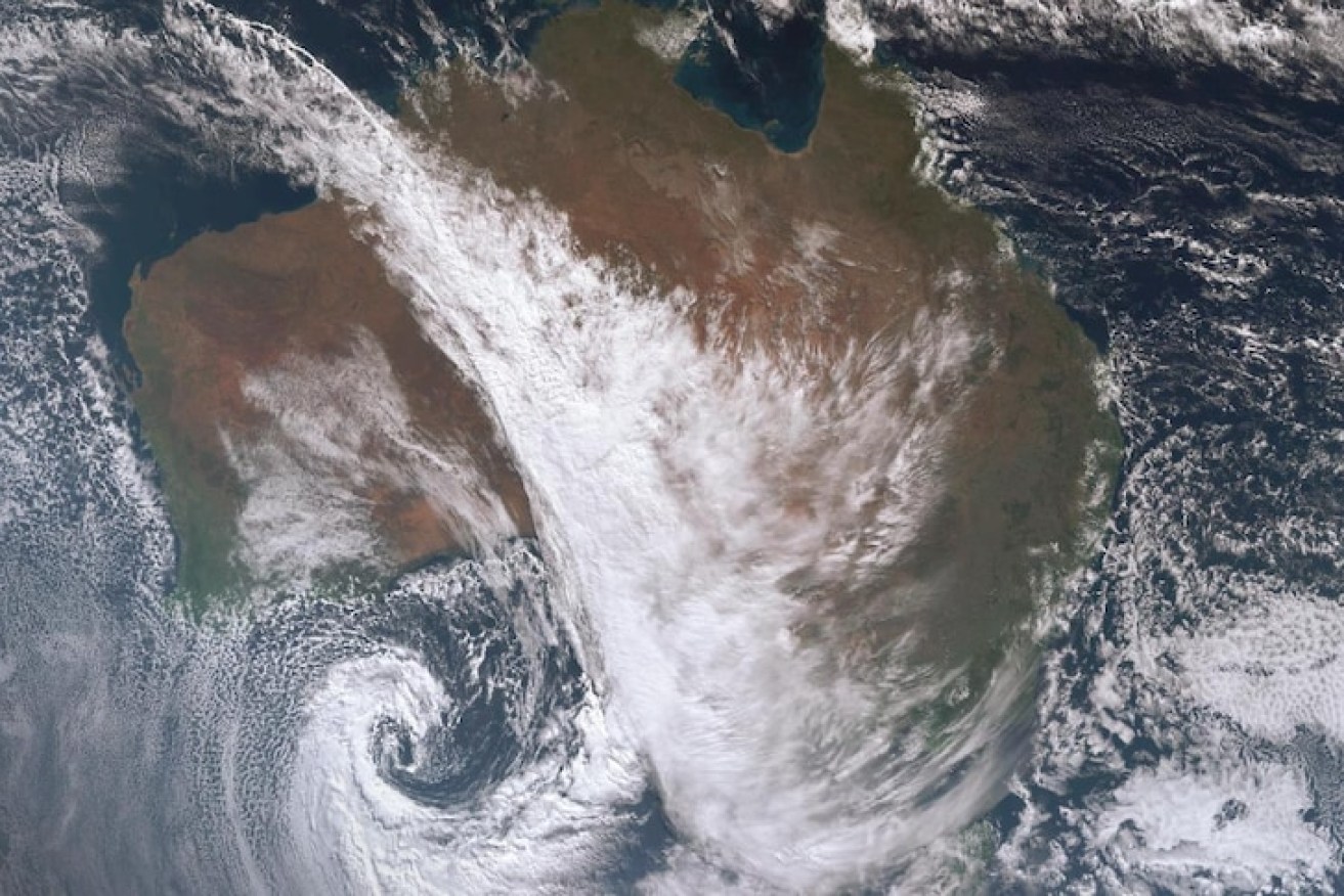
A stream of cloud is currently stretching across the continent and spiralling into a low in the Bight. Photo: Himawari Satellite
A cold front and tropical moisture are teaming up to drag rain from coast to coast, across the desert, this week.
According to senior forecaster at the Bureau of Meteorology Sarah Scully, thunderstorms are forecast to develop on Thursday through south-west Queensland, central New South Wales and even central parts of Victoria.
These storms could be severe, with wind gusts likely to be the biggest factor.
Then there is the rain.
Rain is already falling across the desert and it is about to feed all the way down into the south-east and across into Queensland.
During winter, cold fronts skirting across the south of the continent are a near-weekly occurrence, but rain from the desert to the Dandenongs is not part of the usual script.
The difference this time around is what is known as an “atmospheric river”.
What is an atmospheric river?
University of Melbourne PhD student Kimberly Reid studies atmospheric rivers.
She explains that they are like rivers of water in the sky that transport water, above our heads, at quantities roughly equivalent to the amount of water that flows down the Amazon.
“So they are huge and when they hit mountains or interact with cold fronts, as we are about to observe, they rain out this water and can typically cause heavy rainfall, floods, snow and strong winds.”

Map shows moisture streaming across Australia as it moves further east across the week. Source: Alicia Bentley, University at Albany, New York
Keen watchers of Australia’s weather might be familiar with the term north-west cloud band.
Such a phenomenon is associated but not quite the same thing.
A north-west cloud band is when there is a band of cloud that stretches across Australia from the north-west and typically ties in with a cold front, as is going on at the moment.
North-west cloud bands can exist without being associated with an atmospheric river but they don’t typically bring as much rain.
But when an atmospheric river joins in, it brings extra moisture to the party.
As is happening at the moment.
An atmospheric river is feeding in tropical moisture from the north-west just as a cold front is pushing across the south of the country from west to east.
“You’ve got this warm, moist air in the north-west and then this cold, dry air coming up from the south.
“So, what happens when they interact is the cold air forces the warm air to go up and cool.”
Quite spectacular. pic.twitter.com/isV535zNLQ
— Andrew Miskelly (@andrewmiskelly) June 22, 2021
As the water vapour goes up and cools it condenses into a liquid, generating a huge band of cloud and increasing the chance of rain.
According to Ms Reid, atmospheric rivers are not particularly uncommon because there is usually one in our region around once a week.
And yes, there was one associated with all that recent flooding in Victoria, according to Ms Reid.
Desert rain
The rain has already started to fall across the Pilbara and central desert.
It is a part of the world where rain gauges are few and far between but they have already recorded 31mm at the bureau’s weather station at Giles (from Uluru, keep going west until you cross the West Australian border, then keep going some more).
Not bad for the desert and a promising sign for those hoping for rain further south.
“This is a really good news story for many … agricultural areas of South Australia … as they’ve been missing out on a lot of the rainfall that eastern Australia has been drenched with over the last few months,” Ms Scully said.
Gippsland spared
But perhaps the biggest relief associated with the system this week is who will miss out.
After a thoroughly sodden few weeks, flood-affected regions in Gippsland are not forecast to receive significant rainfall with this rain band, according to Ms Scully.

Widespread rainfall totals between 5mm and 20mm, are tipped, with isolated falls of up to 40mm. Source: Bureau of Meteorology
However, there is a cut-off low spinning up in the wake of the atmospheric river and its path is uncertain at the moment, but the BOM is keeping an close eye on it.
“It looks like the areas to be watched will be south-east South Australia, Victoria and New South Wales.
“Particularly the western and northern windward slopes of Victoria and NSW.”
This system is also forecast to bring dangerous surf conditions along the southern coast, which is set to coincide with the highest astronomical tides, upping the risk of coastal erosion and could even result in the inundation of low-lying areas.
Ms Scully warns those along Spencer’s Gulf and the Gulf of Saint Vincent, including Port Adelaide, to remain alert.
As usual, please keep up to date with the warnings via ABC Emergency and consider packing a dry set of socks if venturing out in the wet this week.
–ABC

Legal rule stops even Hugh Grant from a win in court