Elderly woman swept away, as more Vic evacuations issued
A 74-year-old woman who was swept away in Victorian floodwaters on Monday night is “lucky to be alive” after a man came to her rescue.
Police said the woman was driving in convoy with a friend in Elmore, north-east of Bendigo, when her vehicle was washed off the road into Bendigo Creek at Naughtons Bridge.
It travelled about 100 metres downstream before the Eaglehawk woman was able to make her way to a tree.
A local passer-by, known as Mitch, swam out to the woman several times before he was able to use a ratchet strap to secure her to the tree.
Mitch then stayed with the woman making sure she was okay, for up to an hour, while emergency services responded and headed to the scene.
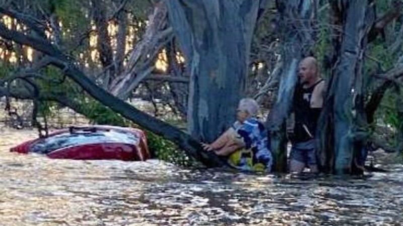
Police thanked the ‘good Samaritan’ who risked his life to jump into the water. Photo: Victoria Police Media
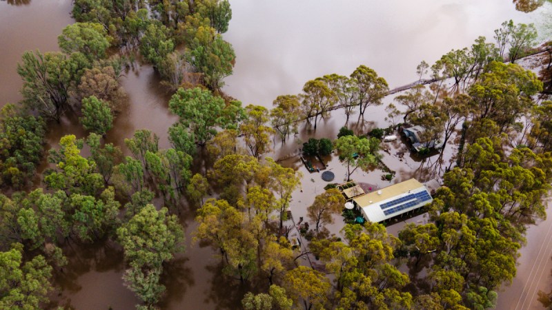
The dramatic rescue unfolded as central Victoria was hit by another flood crisis after record rainfall on Monday.
The town of Rochester, on the Campaspe River, was the latest to be issued with an evacuation notice late Monday as floodwaters were expected to peak at 114.8 metres on Tuesday morning.
Rochester residents were warned to prepare for floodwaters to inundate and isolate their homes.
The alert followed residents of Yea and Seymour, in the Goulburn Valley, being urged to get out while they could.
Residents of Yea were later told on Monday afternoon it was too late to leave.
At Rochester, 35 homes were expected to be inundated as floodwaters were predicted to continue rising overnight and affect the town into Tuesday morning.
Another 200 properties in the town could be surrounded by water.
At Seymour about 50 homes could be inundated and another 200 homes there cut off, Victoria State Emergency Service chief Tim Wiebusch warned.
“They’re the areas most at risk now,” Wiebusch told Nine on Monday night.
“We’re still going to see the severe weather with us for at least another 12 to 18 hours, particularly in the northeast of the state and then the weather clears out.
“But we will see this riverine flooding for at least another four to five days at high-risk levels in some communities.”
Major flood warnings were in place on Tuesday morning for the Campaspe and Goulburn rivers.
More than 180 millimetres of rain in 24 hours was recorded in the central Victoria town of Heathcote, amounting to three months’ worth.
Redesdale’s more than 117 millimetres in 24 hours was a daily record for any month from 120 years of data. The 92 millimetres recorded in Bendigo broke 90-year records.
A house is flooded following heavy rainfall north of Bendigo on Monday. Photo: AAP
A landslide about 40 metres wide and 70 metres long closed the Mount Dandenong Tourist Road at Ferny Creek in Melbourne’s southeast.
It was among hundreds of Victorian roads closed on Monday night.
Victoria Police warned motorists to take care as intense rainfall and flooding continued.
“We’re asking all motorists to please heed the warnings from emergency services – avoid travelling on flood-affected roads and never attempt to drive through flood waters, it could be the last thing you ever do,” road policing assistant commissioner Glenn Weir said.
“All emergency services are working hard to respond to this latest weather event, but we don’t want to be diverting resources to rescue people that have ignored the warnings.”
Several evacuation centres were set up in Victoria on Monday, including at Seymour, Yea, Bendigo, Echuca and Rochester.
A severe weather warning for heavy and locally intense rainfall was in place for people in East Gippsland, parts of West and South Gippsland and the north east forecast districts.
Flooding at Seymour was expected to be higher than in 1993.
SEQ storms
More severe weather is forecast for Queensland’s southeast, as the region still deals with the damage from recent storms.
The Bureau of Meteorology says severe thunderstorms are possible inland of the Gold Coast from Tuesday.
“Severe storms again will bring rainfall as the most likely phenomenon but large hail and damaging winds will be possible through Tuesday as well,” meteorologist Miriam Bradbury said.
Rain is predicted across Queensland’s southeast and northern NSW from Tuesday, but falls are expected to be much lower than the region experienced during recent wild weather.
A tornado hit the Gold Coast on Christmas Day, followed by storms and flash flooding, which also wreaked havoc in the Logan and Scenic Rim regions.
In the severe storms’ aftermath SES reinforcements from NSW and Victoria joined their Queensland counterparts in recovery efforts.
The NSW contingent of about 120 storm and chainsaw specialists has returned home.
“Our dedicated members worked tirelessly alongside Queensland emergency services and residents to clear debris, remove fallen trees, tarp rooftops and door knock to provide essential support to affected individuals and families,” NSW SES acting Commissioner Deb Platz said.
The storms initially left more than 130,000 homes without power in Queensland’s southeast, but work to restore electricity was finally completed on Sunday night.
The race is now on to get damage repaired at about 130 schools across the state before students return on January 22.
Gold Coast City Council launched Operation Clean Up to help clear storm debris and flood damage in the most severely impacted areas.
“We have a plan and we are coming to help,” Mayor Tom Tate said.
“The task ahead of us is mammoth, with an unprecedented amount of green waste to be removed – it is estimated it will take 75,000 truck loads to remove the waste.”
-with AAP

Judge urges reining in of ex Trump lawyer, fixer


Horse saved as more die in Brazil’s floods