North Queensland battens down for big blow
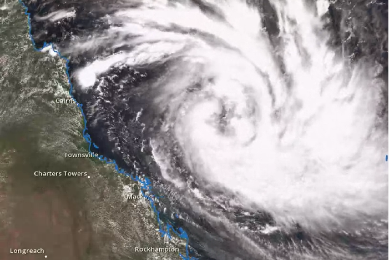
The BOM satellite showing Cyclone Debbie. Photo: BoM
Evacuations have been ordered in coastal towns and communities of the Whitsundays council area in north Queensland as Tropical Cyclone Debbie bears down, with authorities warning of damaging tidal surges.
The system is likely to cross the Queensland coast as the worst cyclone since Yasi hit as a category five in 2011, the Bureau of Meteorology (BOM) warned.
Tropical Cyclone Debbie remains on track to be a severe category four cyclone when it makes landfall on Tuesday morning “somewhere near Ayr”, BOM Queensland regional director Bruce Gunn said at a media briefing with the Premier on Sunday.
He said winds of up to 250 kilometres per hour and significant tidal surges could be expected.
At 1:00pm, the category two system was estimated to be 475 kilometres east north-east of Townsville and 370km east north-east of Bowen, moving west south-west at 8 kilometres per hour.
The BOM said it expected to upgrade Debbie to category three later today.
“I think you could say that Debbie’s probably the most significant tropical cyclone since Yasi that we’ve had to deal with in Queensland,” Mr Gunn said.
“Not so much because of its intensity, we’re only predicting a category four at landfall, but mostly because of its size and extent.”
Tidal surges caused extensive damage when Yasi crossed the coast.
As a result, Whitsunday Disaster Management Group have issued a Watch and Act order for a police-directed evacuation of areas designated red and orange zones under local disaster planning.
Residents are being urged to warn their neighbours, secure their belongings and seek safe shelter.
This covers coastal communities from Cape Upstart, north of Bowen, to Lethebrook, south of Proserpine.

Bottled water was one of the hottest sellers at this Townsville supermarket.
In Home Hill, just north of the Whitsundays evacuation zone, shop owner Ken Hall has been busy sandbagging the front of his business, which is also his home.
“I’ve been in three cyclones before, but this one has made me a little nervous because it’s bigger than the ones I’ve been in, it could be a category four and it’s heading directly for us,” he said.
“I’ve had flood waters up to the step [before] but never higher than that.
“The older folks have told me that it comes up to waist high so I’m a bit concerned for my shop.
“My shop is my home, I have a house out the back — I’ve been on the roof, I’ve cleaned the gutters, I’ve picked up some loose tin, I’ve got sandbags for my back door, that’s about all I can do.”
He said he had plenty of water and dry goods, along with a gas stove for if the power was cut.
Premier Annastacia Palaszczuk said schools from Ayr to Proserpine would be closed on Monday.
“This is a safety precaution as the winds are going to be escalating. With the force of these winds, I do expect further school closures later on during the week,” she said.
She said a full list of closed schools would be available on Sunday afternoon.
Senior forecaster Andrew Carnes said the cyclone’s path was very hard to predict.
“If you’re further north than that Burdekin area and you think we’re out of the woods now — we’re certainly not,” he said.
“It doesn’t take much of a change in the track for towns to be right under the eye or even places further northwards — as far north as Cardwell.
“[We] could still see the coastal crossing from Cardwell all the way down to Proserpine.”

Council workers sandbagging The Strand in Townsville ahead of the storm surge. Photo: ABC
‘Assume the worst’: Townsville Mayor
Townsville Mayor Jenny Hill said residents should not be complacent.
“Over the next few days we have to keep monitoring it and we have to assume the worst, which is why we’re asking people to prepare themselves now in case we require them to evacuate,” she said.
Burdekin Shire Mayor Lyn McLaughlin said some residents had already left the region as a precaution.
She said the council was encouraging people to stay with family and friends elsewhere if they do not feel safe to shelter in their homes.
“We don’t actually have a cyclone shelter in the Burdekin so we are encouraging people who are wanting to shift from their house to stay with family and friends, we know there are people who have left the district to go elsewhere to wait to see what happens,” Cr McLaughlin said.
James Cook University (JCU) cyclone testing station director David Henderson said they were setting up mobile towers to measure wind speeds ahead of the cyclone’s arrival.
“If the system works according to plan each of the towers should be sending back data every 10 minutes as a summary file that goes back to the Met bureau, emergency services, the local councils and some of those summaries are then up on the webpage at the cyclone testing station at JCU,” he said.