Evacuation efforts abandoned ahead of strengthening TC Megan
Source: Facebook/King Ash Bay Fishing Club
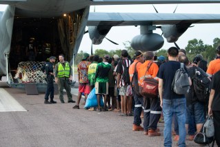
The defence force has abandoned an emergency evacuation of hundreds of people from a remote Northern Territory town after conditions made it too dangerous.
NT Chief Minister Eva Lawler said earlier two Australian Defence Force planes were on their way to Borroloola – inland from the Gulf of Carpentaria – early on Monday.
Tropical Cyclone Megan is expected to hit the town by Monday afternoon, bringing 200km/h winds and hundreds of millimetres of rainfall.
By Monday afternoon, the ADF had been forced to abandon evacuation efforts after multiple attempts to land in the town of 700 people failed due to severe weather.
“The evacuation of Borroloola has been suspended due to the ADF planes not being able to land safely. We’re working with the local emergency management team to keep the community safe,” Lawler wrote on Facebook.
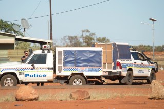
“There are enough buildings in Borroloola that are rated to withstand a category-three cyclone to keep the community safe. These include the police station, the health centre and dozens of homes in the community. The ADF will land at Borroloola when safe to do so.”
NT Police Assistant Commissioner Matt Hollamby said earlier residents were to be flown to the McArthur River Mine airstrip to board bigger planes bound for Darwin. However, he warned the evacuation was not guaranteed.
“The landing at Borroloola will become challenging as the day goes on … They will reach a point where aircraft will not be able to land,” he said.
“We have a contingency plan in the event that the aircraft can’t evacuate all people that want to be evacuated in time. There are 40 residences in Borroloola that are built to code and the remaining residents will need to shelter there.”
Hollamby said about 300 people were waiting at the Roper Gulf Council offices early on Monday, ahead of the first evacuation flights.
TC Megan intensified to a category three on Sunday as it approached the NT coast, amid warnings it might strengthen further.
“There is a very, very low chance it might reach category four but Borroloola is 50 kilometres inland from the coastline and it is anticipated that it will not be a category three intensity when it reaches [there],” Hollamby said.
The cyclone is forecast to hit the NT coast between 3.30-9.30pm on Monday, with the warning area spanning hundreds of kilometres – from Port Roper in the NT, across the Queensland border to Mornington Island.
“Communities and residents in those areas should be on high alert for the strongest of the cyclone impacts – the wind, rain, abnormally high tides and the large seas as well,” BOM senior meteorologist Miriam Bradbury said.
“We do also have an additional severe weather warning current for south-eastern parts of the Gulf [of Carpentaria] coast, in Queensland, and parts of the Gulf Country for abnormally high tides, even outside of the tropical cyclone warning area.”
The core of the cyclone has been called destructive, bringing wind gusts of up to 220km/h and rainfall totals of up to 400 millimetres.
Source: Bureau of Meteorology
Lawler said there was about 500 millilitres of rain at Groote Eylandt on Friday and Saturday.
“Intense rainfall precedes the cyclone and flooding is possible about coastal parts of the Carpinteria district this evening and during the day,” she said.
“Water levels are rising quickly and roads may close on short notice.”
On Monday morning federal Emergency Management Minister Murray Watt confirmed a request from the NT government for ADF personnel to be sent to the region had been approved.
“There is some concern that not only could there be damage from the cyclone itself, in terms of wind gusts to homes in Borroloola, but also there is a risk of some pretty serious flooding,” he told ABC Radio National.
“On that basis, the Northern Territory government requested ADF assistance to assist with evacuations.”
Megan is expected to return to a tropical low as it heads further inland on Tuesday and Wednesday.
-with AAP