Flood-ravaged Queenslanders lashed by rain as cyclone approaches
Source: BoM
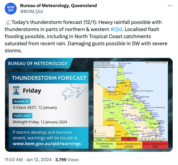
Heavy rain is lashin flood-ravaged far north Queensland on Friday, prompting a severe weather warning for the north tropical coast and tablelands near Cairns.
The region, still recovering from record flooding caused by Tropical Cyclone Jasper just weeks ago, is bracing for more floods with another cyclone threat looming.
“Heavy rainfall which may lead to flash flooding is developing between an area from Port Douglas to Daintree, possibly extending northwards to Wujal Wujal by late morning,” the Bureau of Meteorology warning said.
“Six-hourly rainfall totals between 140 and 180mm are possible.”
All roads are closed north of the Daintree River near Cairns due to landslips and rockfalls after again being hit hard by heavy rain.
Daintree village has recorded 234mm, with a severe weather warning issued for the north tropical coast and tablelands on Friday.
It was later cancelled but the Bureau of Meteorology warned there was a chance of more downpours on Friday night.
Overnight rain damaged a supply main, prompting water restrictions for Port Douglas, Mossman and Newell Beach areas.
“We can’t stress enough how important it is for everyone to respect the new restrictions to protect our already vulnerable water supply,” Douglas Shire Council’s Scott Mason said.
The far north is still recovering from record flooding caused by Tropical Cyclone Jasper just weeks ago.
However, their efforts to rebuild may be hampered by the latest round of wet weather.
“Over the coming days heavy rainfall, severe thunderstorms and flash or riverine flooding are all risks we can expect,” the Bureau’s Miriam Bradbury said.
There are flood warnings current for six rivers across north Queensland, with possibly another cyclone on the way.
A monsoon trough in the Gulf of Carpentaria may form a tropical low on Friday, with a low chance of developing further into a tropical cyclone on Sunday.
“If the conditions are right and these systems stay over water long enough they may deepen into tropical cyclones,” Ms Bradbury said.
“Whether or not they do become tropical cyclones, we are still expecting a heavy rainfall and flooding risk across northern parts of Australia.”
The wet weather has returned as communities try to rebuild in Jasper’s aftermath.
Record flooding caused by the cyclone destroyed homes and prompted the evacuation of about 300 people from Wujal Wujal.
Federal Emergency Management Minister Murray Watt hoped the latest wet weather did not derail the far north’s massive recovery effort.
“Even without possibly more cyclones, there is more rain forecast for those areas … so there is a risk of some more minor flooding,” he said.
“Our motto is always ‘hope for the best and prepare for the worst’ and that’s what people are doing now.”
Cairns Mayor Terry James said he was concerned more flooding would impact his region with heavy rain set to coincide with king tides.
“Absolutely. Our biggest fear is complacency … (but) I think after the last event people will sit up and listen,” he said.
More than 121,000 people in Queensland have received some $22 million in disaster recovery payments. (Jono Searle/AAP PHOTOS)
The Cairns region is still counting the cost of the last floods, with Mr James predicting it would take up to two years to repair the damage.
Residents hit hard by Jasper have another four weeks to apply for financial assistance.
More than 121,000 people across the state have already received almost $22 million in disaster recovery funding.
Queensland’s southeast is also rebuilding after seven people died in storm-related incidents over the Christmas period.
The state’s repair bill has been estimated at $2 billion but is expected to rise.


