Pre-winter cold snap hits Australian capital cities
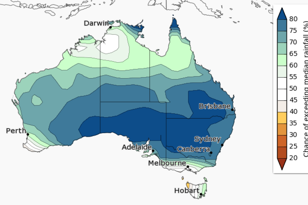
Higher than average rainfall is likely across Australia from June to August. Photo: BoM
The majority of Australia’s capital cities will shiver through the rest of the week, as huge swathes of the nation well and truly say goodbye to the record hot summer and autumn.
Residents in Melbourne, Sydney, Adelaide, Canberra, Hobart and even Perth will be forced to rug up over the next few days.
Hobart will have the lowest temperature of the chilly cities, but despite the national frosty spell, the Bureau of Meteorology warned that for many areas winter would not be similarly cold.
• Open season: Katter calls for croc safaris
• Record summer fuels hot hangover for Aussie autumn
• A week of extreme weather sees out 2015
Rainfall was set to be above average from June to August, the Bureau of Meteorology predicted in its recently released monthly and seasonal outlook.
The temperatures were a welcome change from the sweltering hangover most of the nation experienced during March and April.
Scroll down to see the forecast for your capital city
The southern mainland would be cooler with rainfall for “large parts” of mainland Australia to be up.
The chance of rainfall being higher than the median was biggest in central NSW, SA and southern Queensland.
It was also more than a 50 per cent chance in metropolitan Melbourne, Hobart, Sydney, Canberra, Adelaide, Brisbane and Perth.
Minimums in Canberra, Melbourne and Hobart were forecast to get into single figures over the next week.
Melbourne’s forecast low of 3C for Tuesday morning would be the chilliest mark recorded since before June 2007.

Higher than average rainfall is likely across Australia from June to August. Photo: BoM
BoM forecaster Rob Taggart told the ABC general temperatures in Sydney were the coldest since August last year, while most sites across the state recorded the coldest May morning in about five years.
He said the chilly weather had been caused by a cold front.
“We’ve had a front come through and that’s brought some dry southerly winds,” he said.
Rain was expected to hit all capital cities except Darwin during the next week, with Sydney and Canberra set to be the worst hit by downpours.
There would be “warmer than average daytime temperatures for the tropical north and parts of southeast Australia” during winter, BoM said.
Sydney
Tuesday: 19C
Wednesday: 18C
Thursday: 19C
Friday: 18C
Saturday: 19C
Melbourne
Tuesday: 16C
Wednesday: 16C
Thursday: 16C
Friday: 16C
Saturday: 16C
Adelaide
Tuesday: 18C
Wednesday: 18C
Thursday: 17C
Friday: 17C
Saturday: 18C
Hobart
Tuesday: 13C
Wednesday: 14C
Thursday: 15C
Friday: 15C
Saturday: 15C
Perth
Tuesday: 19C
Wednesday: 19C
Thursday: 20C
Friday: 21C
Saturday: 18C
Canberra
Tuesday: 15C
Wednesday: 14C
Thursday: 16C
Friday: 15C
Saturday: 15C
Darwin
Tuesday: 34C
Wednesday: 34C
Thursday: 34C
Friday: 34C
Saturday: 33C
Brisbane
Tuesday: 24C
Wednesday: 24C
Thursday: 23C
Friday: 24C
Saturday: 24C
– with ABC