NZ’s most popular hike in Hobbit country

It may be New Zealand’s most popular one-day trek, but a successful crossing of Tongariro National Park is far from guaranteed.
“This is my third attempt to get to the other side,” I overhear an Australian tourist saying on a bus hurtling along a road from the city of Taupo in the geographical heart of the North Island to the trek’s starting point at the western side of the park.

Picture: Ian Lloyd Neubauer
The most common obstacle encountered by those attempting the 19km high-altitude slog through the volcanic region that featured in Peter Jackson’s The Lord of the Rings and Hobbit trilogies is not a lack of preparation, though there are no shortage of trekkers who fail take even the most basic precautions.
• The 10 best feelings only travellers understand
• One weekend in the USA’s biggest party town
• Aussie cities named the world’s ‘most friendly’
The most common impediment is the weather: wet and temperamental as it is all over New Zealand but with the added risk of snowfall, blizzards, impenetrable fog and sub-zero temperatures, not to mention sporadic volcanic eruptions that hurtle rocks the size of cars through the air.

Picture: Ian Lloyd Neubauer
Into the valley of darkness
“The weather is going to be fabulous – but only for the first half of the day,” our bus driver says. “A storm front is moving through in the early afternoon so don’t tarry on the way up. Get to the top, have a look around and then start your descent as early as early as possible.
“But you’re going to need a warm waterproof jacket. I’ll be checking to make sure each of you have one as you get off the bus. If you don’t have one, you’ll need to hire one from us. Otherwise you’re not getting off this bus.” He adds: “And if you hear a loud rumble or see a huge plume coming out of a cone on the way up, do NOT continue. Turn around, I’ll be waiting for you here. That way you’ll get to live to attempt the crossing another day.”
With the formalities over, we lace up our hiking shoes and put our heels to the track. The landscape is epic from the get-go: a wide, windswept valley carpeted with tussock grasslands sown with bright yellow mountain buttercup, purple lavender and white daisies. The 100-odd trampers in our bus disperse along a donkey trail that alternates from a raised wooden pathway to a series of posts delineating invisible lines across rocky lava fields formed as early as 1975.
At the two-hour mark my guide and I detour to a small waterfall to fill our drinking bottles. You don’t need a guide to attempt the Tongariro Alpine Crossing outside of winter, but mines proves helpful nevertheless, explaining how the water in the crystal clear streams we cross in the valley contain high levels of dissolved minerals content and is not suitable to drink.
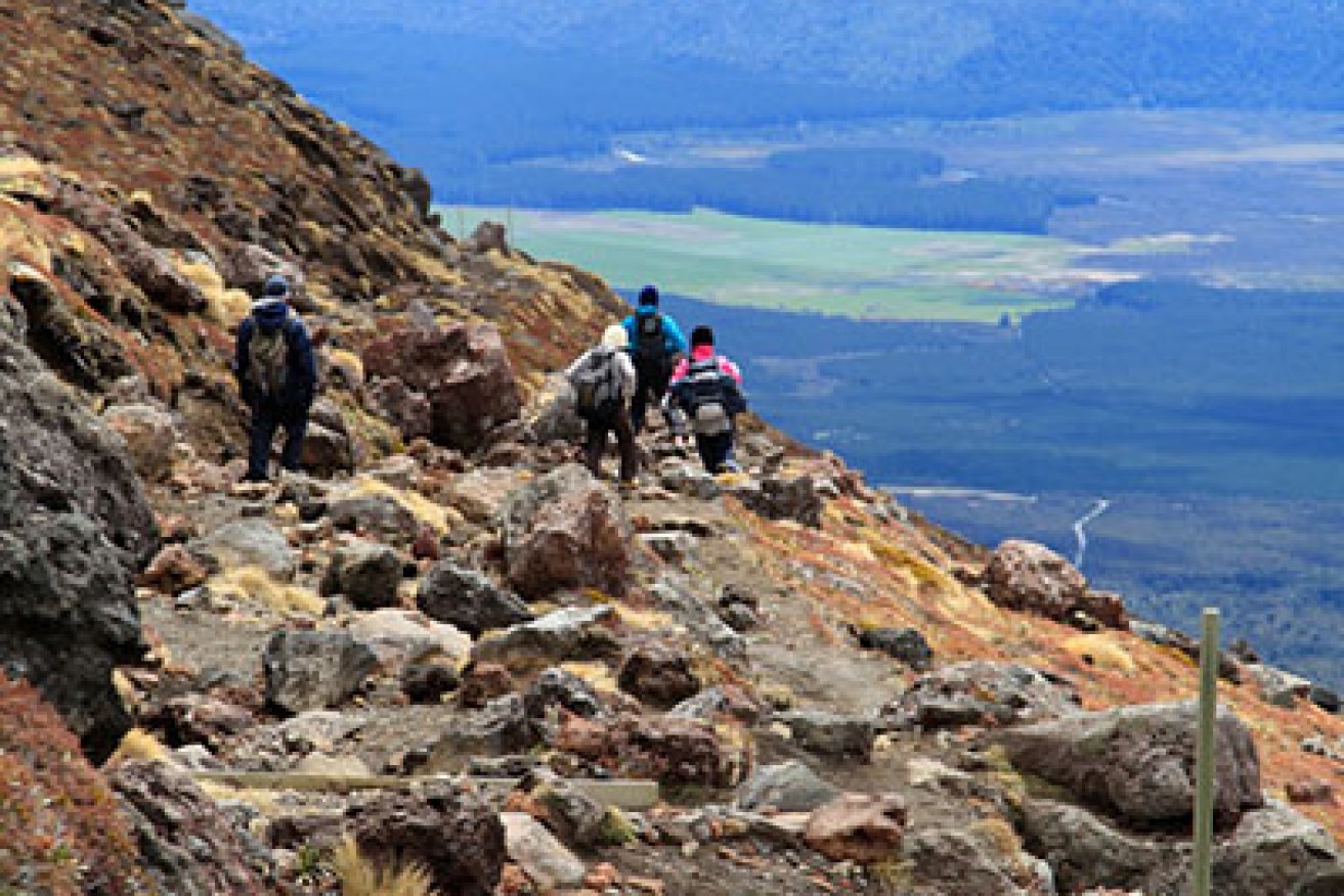
The going gets a lot tougher when we hit the Devil’s Staircase – a seemingly never-ending flight of rock-hewn stairs that combined with the thinning of oxygen at 1,350m literally takes our breath away. I slow to a crawl, stopping frequently to catch my breath and to gawk at the magnificent view.
To the west I can see the Mangatepopo Valley from whence we came and as far back to the west coast. To the north and east stand 200m sheer granite walls that form the base of Mount Tongariro. And to the south I see the most magnificent topographical feature of them all: Mount Ngauruhoe, the 2,300m snow-capped volcano Peter Jackson fans will recognise as Mount Doom.

Picture: Ian Lloyd Neubauer
Craterland
When the staircase comes to an end it spits us into the South Crater, an glacially carved basin with an eruption pit in its centre formed some 14,000 years ago. Tongariro’s most recent eruption took place on August 6, 2012, when the nearby Te Maari Crater blew its stack and saw the park closed for three months.

Picture: Ian Lloyd Neubauer
“We are always mindful of the risks it poses to people who use the track,” New Zealand’s Department of Conservation said during the closure. “It’s an active volcanic area, and while this is an intrinsic part of its attraction to visitors, it poses challenges for all as we try to balance the public risks and benefits associated with it.”
After passing a signpost indicating the last turn-around spot in case of bad weather, we climb to the rim of the Red Crater. Its colour is a symptom of the high-temperature oxidation of iron in the rock, whereas the rotten-egg stench that hangs in the air is caused by sulphur gas that rises apparition-like from fumaroles and geysers on the surface.
The track climbs and climbs to a snow-covered ridge that reaches 1,886m – the highest point in the crossing.
There, it drops like a bomb into the Central Crater where I see Emerald and Blue Lakes, mineral lakes that are sacred to the indigenous Maori of New Zealand. Glowing surreally within the centre of black and white gravel pits, the lakes are so dazzling it doesn’t come as a surprise to learn they are the most photographed place in all of New Zealand.

Picture: Ian Lloyd Neubauer
The weather turns for the worse as we clear the Central Crater and begin our descent along the northern face of Mount Tongariro. Light rainfall and fog cloud our vision, the temperature plummets and powerful gusts of wind batter us relentlessly as we zigzag towards the finishing line.
An hour or so later we come across a boy, perhaps 11 or 12 years old, followed a few minutes later by another boy half his age who is in turn followed by his parents. They are Europeans – either German or Swiss – and they are not carrying not as much as a bottle of water between them. My guide tries to convince them to turn back, telling them that even if they make it to the Emerald Lake, the fog is now so thick up there they won’t see a thing. They dither at first but then reluctantly agree, but not the father takes off for a jog up the mountain to collect his children, who are several hundred metres ahead.
“Every year they have to haul tourists off the mountain who don’t prepare properly, and nearly every year, someone dies from exposure,” my guide tells me. “Some people just don’t get it. I’ve seen tourists up here in thongs and carrying their lunch in a plastic bag.”
The finishing line
By the time we reach the final resting stop at Ketahiti Hut it’s snowing. We dart in for shelter to find another dozen-odd trekkers doing the same thing. Like the family we passed earlier, most of them had started the crossing at the finishing line – a significantly steeper route – and were now coming to terms with the fact that their wasn’t a snowballs chance in hell they were going to make it to Emerald Lake and back without freezing to death.
The weather becomes milder during the final two-hour descent where we find ourselves inside a humid rainforest brimming with birdlife. It’s a matter of some relief when we reach the finish line and make a beeline for the warm bus. “Think about what everything you saw today,” our driver says as we hurtle back to Taupo. “Wasn’t it fantastic?”
Then a voice from a seat behind me: “It was the most beautiful place I’ve ever done in my life. I’m glad I was well prepared for it.”
Factfile
Tongariro Expeditions (call +64 7377 0435) offer daily transfers from Taupo to Tongariro National Park for NZ$65 from October and June.
In the winter months, the fee climbs to NZ$170 and includes a compulsory guide, cramp-ons, ice axes and raincoats.
Click here for detailed information on the crossing.
Click here for essential weather forecasts.